Leica DISTO™ - How to use the P2P Function? Best measuring tool for inaccessible objects 2019
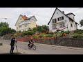
In many situations, especially outdoors, distances have to be measured where you may not have direct access. Objects may be at a certain height or in a position where you cannot get close enough to one of the target points. Point-to-point (P2P) measurement technology overcomes this issue. Similar to a total station, it allows for distance measurements between two points from one location.
Видео Leica DISTO™ - How to use the P2P Function? Best measuring tool for inaccessible objects 2019 канала Leica Geosystems AG
Видео Leica DISTO™ - How to use the P2P Function? Best measuring tool for inaccessible objects 2019 канала Leica Geosystems AG
Показать
Комментарии отсутствуют
Информация о видео
Другие видео канала
 Measure horizontally over obstractions with the Leica DISTO with the Smart Horizontal Mode
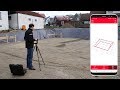 Leica DISTO™ Plan App - How to use the Earthworks Function
 Pomiary szkieletu 3D dalmierzem #Leica #Disto S910 w programie iCON Office - #BIM 3D
 Best outdoor measuring tools 2019
 Leica Geosystems | DISTO™ S910 - P2P and CAD Integration
 OrthoGraph 3D measurement in real life situation
 Leica DISTO S910: How to do a P2P Application
 Leica DISTO S910 Review
 How to check accuracy of DISTO S910 for P2P measuring
 Leica DISTO™ Plan App - How to measure a facade
 Leica S910 breve tutorial di utilizzo
 Leica DISTO™ Plan App - How to use the Export function
 Leic Disto S910 távolságmérő - 3D felmérés és DXF mentés
 How to use Leica DISTO™ S910 with the new Zeno 20 (gamtec)
 Leica Disto D510 Demo Video
 Leica DISTO X4 Outdoor Laser Distance Meter | Engineersupply
 Leica DISTO™ S910 - how to use Data Capture in DXF
 Mesurer un local avec un disto Leica X3 X4 et le Leica DST360
 Leica DISTO™ S910 for Building Surveyors