What can GPS tell us about future earthquakes in Cascadia? (UNAVCO collaboration)
This animation is used by permission of UNAVCO for this Pacific Northwest Playlist. (Visit other UNAVCO animations and videos: https://www.youtube.com/channel/UC1uOu5gkvJnaiacLj9k3z0w )
Cascadia Megathrust earthquake? GPS stations along the coast of Japan had been moving to the west before the March 11, 2011 earthquake, and rebounded back to the east following the earthquake. This animation compares that subduction zone with a mirror-image subduction zone in the Pacific northwest by illustrating how the shallow portion of the Cascadia plate boundary is locked by friction thus compressing the overlying North American Plate in a NE direction during subduction of the Juan de Fuca Plate. Using a spring to emphasize the strain within the overlying plate, we will see the displacements of GPS receivers along the entire leading edge of the North America continental margin. Ultimately, the continental margin will rebound suddenly to the southwest as the stored elastic energy is released for the first time since the last great Cascadia earthquake on January 26, 1700
EarthScope, UNAVCO, CEETEP, IRIS collaboration
www.earthscope.org, www.unavco.org, www.iris.edu
Funded by the National Science Foundation
Animation & graphics by Jenda Johnson, Earth Sciences Animated
Directed by Robert Butler, University of Portland
Narrated by Roger Groom, Mount Tabor Middle School
Reviewed by Beth Pratt-Sitaula and Robert Lillie
Видео What can GPS tell us about future earthquakes in Cascadia? (UNAVCO collaboration) канала IRIS Earthquake Science
Показать
Комментарии отсутствуют
Информация о видео
Другие видео канала
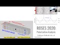 Remote Online Sessions for Emerging Seismologists (ROSES): Unit 6 - Polarization Analysis
 UsArray Vizualizations Tutorial
 ¿Cómo se compara Marte con la Tierra?
 Interviews with seismologists—Dr. Derek Schutt, Colorado State University
 Earthquake Ground Motion Animation February 21, 2008 Nevada
 Remote Online Sessions for Emerging Seismologists (ROSES): Unit 9 - Bayesian Inversion
 Seismogram of an Elk Running
 Florence Bascom—1st American Female Geologist (1862–1945)
 Social Media for Scientists
 Volcano Variety: Understanding Arcs with Multi Scale Seismic Imaging
 Incorporating IRIS-held Data into Research Workflows
 FuSG Workshop Webinar - Earth structure, rheology and geodynamics
 Japan and Pacific Northwest Earthquakes (Part 3 of 4)
 Reflections of a Peripatetic Seismologist: Making Broader Impact Deeper
 Anatomy of a Megathrust Earthquake Rupture - The 2010 M8.8 Chile Quake
 Plenary Session - Science Grand Challenges Introduction - 2014 IRIS Workshop
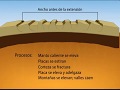 Cuenca y cordillera (Basin and Range) SPANISH
 Tectonics & Earthquakes of the Lesser Antilles (educational; 2020)
 Build Your Own Seismograph Activity—Creating Earthquake "Signatures"
 LA ESPAÑOLA—Tectónica e Historia de Terremotos