【4K】Driving Pacific Coast Highway (PCH) - Long Beach to Laguna Beach in California, USA
State Route 1 (SR 1) is a major north–south state highway that runs along most of the Pacific coastline of the U.S. state of California. At a total of just over 656 miles (1,056 km), it is the longest state route in California. SR 1 has several portions designated as either Pacific Coast Highway (PCH), Cabrillo Highway, Shoreline Highway, or Coast Highway. Its southern terminus is at Interstate 5 (I-5) near Dana Point in Orange County and its northern terminus is at U.S. Route 101 (US 101) near Leggett in Mendocino County. SR 1 also at times runs concurrently with US 101, most notably through a 54-mile (87 km) stretch in Ventura and Santa Barbara counties, and across the Golden Gate Bridge.
PCH enters Los Angeles County and the city of Long Beach after crossing the San Gabriel River. SR 1 then continues northwest through the city to its junction with Lakewood Boulevard (State Route 19) and Los Coyotes Diagonal at the Los Alamitos Circle, more than 2 miles (3.2 km) from the coast. From the traffic circle, it continues inland west through Long Beach, including approximately one mile adjacent to the southern boundary of Signal Hill. PCH is marked as such in Long Beach, but originally bore the name of Hathaway Avenue east of the traffic circle and State Street west of there. PCH then passes through the Los Angeles districts of Wilmington and Harbor City. While bypassing the immediate coastline of Palos Verdes, SR 1 continues to head west into the cities of Lomita and Torrance along the route of the former Redondo-Wilmington Boulevard
PCH then turns north through Redondo Beach and Hermosa Beach. Upon entering Manhattan Beach, it becomes Sepulveda Boulevard and turns back into PCH designation through El Segundo. At Imperial Highway, it regains the name Sepulveda Boulevard as it descends and passes under two runways of Los Angeles International Airport (LAX) via the Sepulveda Boulevard Tunnel.
At its southernmost end in Orange County, SR 1 terminates at I-5 in Capistrano Beach in Dana Point. It then travels west into the city center. After leaving Dana Point, Pacific Coast Highway (PCH) becomes simply "Coast Highway" while at the same time continues northwest along the coast through Laguna Beach (where it meets the southern terminus of SR 133) and Crystal Cove State Park.
SR 1 then enters Newport Beach and passes through several affluent neighborhoods, including Newport Coast and Corona Del Mar, spans the entrance to the Upper Newport Bay, which marks the boundary between East Coast Highway and West Coast Highway, and crosses California State Route 55 near its southern terminus. Upon entering Huntington Beach, SR 1 regains the Pacific Coast Highway designation. It passes Huntington State Beach and the southern terminus of California State Route 39 before reaching Bolsa Chica State Beach and the Bolsa Chica Ecological Reserve. PCH then continues along the coast into Seal Beach, the final city on its journey in Orange County.
🎧 This video contains Binaural Audio. Please wear headphones for best immersive experience.
📅 Recording Date: April 2020
🌠Become a TravelPass Club Founding Member for FREE.
🌠When you sign up, you get free access to the lowest, non-public rates up to 60% on hotels and travel worldwide.
🌠Sign up for FREE using this link:
https://vrlps.co/meN6HRz/cp
►►►Support My Channel◄◄◄
If you enjoy watching my videos and want to support my future travels, please visit:
Patreon: https://www.patreon.com/windwalktravelvideos
Paypal: https://goo.gl/zuC4ZZ
Let's Connect:
►Subscribe: https://goo.gl/sS5fQZ
►Patreon: https://patreon.com/WindWalkTravelVideos
►Facebook: https://facebook.com/WindWalkTravelVideos
►Twitter: https://twitter.com/WindWalkTravels
►Instagram: https://instagram.com/WindWalkTravelVideos
►Reddit: https://reddit.com/r/WindWalkTravelVideos
►Tumblr: https://windwalktravelvideos.tumblr.com
#PacificCoastHighway #PCH #PCH1 #California #4K
Видео 【4K】Driving Pacific Coast Highway (PCH) - Long Beach to Laguna Beach in California, USA канала Wind Walk Travel Videos ʬ
Показать
Комментарии отсутствуют
Информация о видео
5 апреля 2020 г. 0:34:50
00:55:36
Другие видео канала
![[Full Version] Driving Pacific Coast Highway From Santa Barbara to Santa Monica, California, USA, 4K](https://i.ytimg.com/vi/pfTFTAgiRO0/default.jpg) [Full Version] Driving Pacific Coast Highway From Santa Barbara to Santa Monica, California, USA, 4K
[Full Version] Driving Pacific Coast Highway From Santa Barbara to Santa Monica, California, USA, 4K
![[4K] Downtown Palm Springs, California USA 2021 Walking Tour & Travel Guide 🎧 Binaural Sound](https://i.ytimg.com/vi/L2sa3zejgZY/default.jpg) [4K] Downtown Palm Springs, California USA 2021 Walking Tour & Travel Guide 🎧 Binaural Sound
[4K] Downtown Palm Springs, California USA 2021 Walking Tour & Travel Guide 🎧 Binaural Sound 4K Scenic Drive - US Route 101, Pacific Coast, Oregon - 3 Hour of Road Drive with Relaxing Music
![[Full Version] Driving Downtown Los Angeles DTLA, California, USA, 4K UHD](https://i.ytimg.com/vi/Uh8maUM1OIQ/default.jpg) [Full Version] Driving Downtown Los Angeles DTLA, California, USA, 4K UHD
[Full Version] Driving Downtown Los Angeles DTLA, California, USA, 4K UHD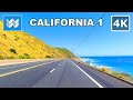 【4K】Scenic Drive: Point Mugu - Malibu - Santa Monica via Pacific Coast Highway / California 1 South
 4K Drive Through English Countryside Buxton, Bakewell, Matlock Bath
 Driving Downtown - San Francisco 4K - USA
 Palm Beach 4K - Mar-a-Lago Billionaire Resort - Scenic Drive
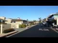 Emerald Bay - Laguna Beach - Drive through streets - Feb 2016
 Arches National Park 4K - Scenic Drive - Utah USA
 Driving in Switzerland 6: From Grindelwald to Lauterbrunnen | 4K 60fps
 Drive 4K - Pacific Coast Highway - USA
 🚴 Venice Beach ● Santa Monica ● Pacific Palisades - Virtual Cycling Bike Ride - California USA 【4K】
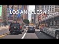 Driving Downtown - Los Angeles 4K - USA
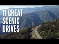 11 Great Scenic Drives in California
 Norway’s $47BN Coastal Highway
 Oceanside Beach Pier in San Diego County, California USA - Walking Tour - 2020 Travel Guide 🎧【4K】
 Florida Keys 4K - Tropical Islands - Scenic Drive
 Las Vegas 4K - Sunset Drive