Drive 4K - Pacific Coast Highway - USA
Sunday Afternoon Drive along the Pacific Coast Highway in Orange County Los Angeles area of California.
The Pacific Coast Highway, State Route 1 (SR 1), is a major north–south state highway that runs along most of the Pacific coastline of the U.S. state of California. At a total of just over 655.8 miles (1,055.4 km), it is the longest state route in California. SR 1 has several portions designated as either Pacific Coast Highway (PCH), Cabrillo Highway, Shoreline Highway, or Coast Highway. Its southern terminus is at Interstate 5 (I-5) near Dana Point in Orange County and its northern terminus is at U.S. Route 101 (US 101) near Leggett in Mendocino County. SR 1 also at times runs concurrently with US 101, most notably through a 54-mile (87 km) stretch in Ventura and Santa Barbara counties, and across the Golden Gate Bridge.
The highway is designated as an All-American Road. In addition to providing a scenic route to numerous attractions along the coast, the route also serves as a major thoroughfare in the Greater Los Angeles Area, the San Francisco Bay Area, and several other coastal urban areas.
SR 1 was built piecemeal in various stages, with the first section opening in the Big Sur region in the 1930s. However, portions of the route had several names and numbers over the years as more segments opened. It was not until the 1964 state highway renumbering that the entire route was officially designated as SR 1. Although SR 1 is a popular route for its scenic beauty, frequent landslides and erosion along the coast have caused several segments to be either closed for lengthy periods for repairs, or re-routed inland.
Orange County
At its southernmost end in Orange County, SR 1 terminates at I-5 in Capistrano Beach in Dana Point. It then travels west into the city center. After leaving Dana Point, SR 1 continues northwest along the coast through Laguna Beach (where it meets the southern terminus of SR 133) and Crystal Cove State Park.
SR 1 then enters Newport Beach, where it is known as simply Coast Highway. It passes through several affluent neighborhoods, including Newport Coast and Corona Del Mar, spans the entrance to the Upper Newport Bay, which marks the boundary between East Coast Highway and West Coast Highway, and crosses California State Route 55 near its southern terminus. Upon entering Huntington Beach, SR 1 regains the Pacific Coast Highway designation. It passes Huntington State Beach and the southern terminus of California State Route 39 before reaching Bolsa Chica State Beach and the Bolsa Chica Ecological Reserve. PCH then continues along the coast into Seal Beach, the final city on its journey in Orange County.
https://en.wikipedia.org/wiki/California_State_Route_1
Видео Drive 4K - Pacific Coast Highway - USA канала J Utah
Показать
Комментарии отсутствуют
Информация о видео
Другие видео канала
 SAN FRANCISCO - CALIFORNIA 8K
 Driving From Nice to Monaco
 FLYING OVER BERMUDA (4K UHD Version!) Ambient Aerial/Drone Film + Music by Nature Relaxation™
 Grand Circle Tour I - Ep 21 - US Highway 163 & Monument Valley
 ENTERING MANHATTAN ON GEORGE WASHINGTON BRIDGE FROM NEW JERSEY
 VANCOUVER | BRITISH COLUMBIA , CANADA - A TRAVEL TOUR - 4K UHD
 Moscow Russia 4K. Capital of Russia
 Things to know BEFORE you go to LOS ANGELES - LA Travel Tips 2020
 Drive 4K - America's Most Popular Park - USA
 California Road Trip - The Pacific Coast Highway
 Toronto 4K - Sunset Drive - Driving Downtown
 LOS ANGELES - CALIFORNIA HD
 Driving the Alaska Highway - Real Time
 Train Ride from Los Angeles to San Francisco
 3D Drive - Winter Storm - VR180
 Driving Downtown - Hollywood Sign 4K - USA
 California Coast Road Trip | San Francisco to San Diego | Itinerary and tips | lifeofreilly.tv
 London 4K - Skyscraper District Drive - City of London
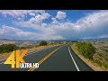 4K Scenic Byway 12 | All American Road in Utah, USA - 5 Hour of Road Drive with Relaxing Music
 Walking from Venice Beach to Santa Monica Pier in Los Angeles, California 【4K】