Tropical Update Fuijiwhara Effect BIG CHANGES
Tropical Update Fuijiwhara Effect BIG CHANGES.
watch https://youtu.be/9xciaaFy77Q
REMEMBER THIS CAN CHANGE
Hurricane Marco.
A Tropical Storm Warning has been issued from Cameron to
west of Morgan City, Louisiana.
SUMMARY OF WATCHES AND WARNINGS IN EFFECT:
A Storm Surge Warning is in effect for....
* Morgan City Louisiana to Ocean Springs Mississippi
* Lake Borgne
A Hurricane Warning is in effect for...
* Morgan City Louisiana to the Mouth of the Pearl River
A Storm Surge Watch is in effect for...
* Sabine Pass to Morgan City Louisiana
* Ocean Springs Mississippi to the Mississippi/Alabama border
* Lake Pontchartrain and Lake Maurepas
A Hurricane Watch is in effect for...
* Intracoastal City to west of Morgan City
* Lake Pontchartrain, Lake Maurepas, and Metropolitan New Orleans
A Tropical Storm Warning is in effect for...
* Mouth of the Pearl River to the Mississippi/Alabama border
* Lake Pontchartrain, Lake Maurepas, and Metropolitan New Orleans
* Cameron to west of Morgan City
A Tropical Storm Watch is in effect for...
* Mississippi/Alabama border to the Alabama/Florida border.Marco is moving
toward the north-northwest near 13 mph (20 km/h), a turn to the
northwest is expected later tonight followed by a turn to the
west-northwest by Monday night. On the forecast track, Marco will
be near the Louisiana coast Monday afternoon, and move near or
over the coast through Tuesday.
Maximum sustained winds are near 75 mph (120 km/h) with higher
gusts. Little change is strength is expected over the next 24 h.
Gradual weakening is expected thereafter, and Marco could become a
remnant low by Tuesday night.
Hurricane-force winds extend outward up to 15 miles (30 km) from the
center and tropical-storm-force winds extend outward up to 105 miles
(165 km).STORM SURGE: Morgan City LA to Mouth of the Mississippi River...4-6 ft
Mouth of the Mississippi River to Ocean Springs MS including Lake
Borgne...3-5 ft
Lake Pontchartrain and Lake Maurepas...2-4 ft
Intracoastal City LA to Morgan City LA...2-4 ft
Sabine Pass to Intracoastal City...1-3 ft
Ocean Springs MS to the AL/FL Border including Mobile Bay...1-3 ft .RAINFALL: Marco is expected to produce total rainfall accumulations
of 3 to 5 inches with isolated maximum amounts of 7 inches across
the Central U.S. Gulf coast through Tuesday. RAINFALL: TORNADOES: An isolated tornado is possible early Monday morning
near the southeast Louisiana coast. Isolated tornadoes are possible
across southeast Louisiana, southern Mississippi, southern Alabama,
and the Florida Panhandle Monday and Monday night.
Tropical Storm Laura.......
A Tropical Storm Warning is in effect for...
* Entire coast of the Haiti
* Inagua and the Ragged Islands in southeastern Bahamas
* Little Cayman and Cayman Brac
* Cuban provinces of Camaguey, Las Tunas, Holguin, Guantanamo,
Santiago de Cuba, Granma, Ciego De Avila, Sancti Spiritus, Villa
Clara, Cienfuegos, Matanzas, Mayabeque, La Habana, Artemisa, Pinar
del Rio, and the Isle of Youth
A Tropical Storm Watch is in effect for...
* Florida Keys from Craig Key to Key West and the Dry Tortugas.
RAINFALL: Laura is expected to produce the following storm total
rainfall accumulations through Tuesday:
Dominican Republic, Haiti, Jamaica, and Cuba: 4 to 8 inches, with
maximum amounts of 12 inches.
Cayman Islands: 2 to 4 inches, maximum amounts of 6 inches.
Florida Keys, Turks and Caicos and southeast Bahamas: 1 to 2 inches.
Across the Greater Antilles this heavy rainfall could lead to
life-threatening flash and urban flooding, and the potential for
mudslides.
By later Wednesday into Friday Laura is expected to produce rainfall
of 5 to 10 inches, with isolated maximum amounts of 15 inches across
portions of the west-central U.S. Gulf Coast near the Texas and
Louisiana border north into portions of the lower Mississippi
Valley. This rainfall could lead to flash, urban, and small stream
flooding. WIND: Tropical storm conditions are expected within portions of the
warning area in Haiti through this evening. Tropical storm
conditions are expected within portions of the warning area in Cuba
later tonight through Monday. Tropical storm conditions are expected
in Little Cayman and Cayman Brac on Monday. Tropical storm
conditions are possible within portions of the watch area in the
Florida Keys Monday.
To donate for my work my paypal link is below. Thank You.
https://www.paypal.com/biz/fund?id=76PY2BSP84RLW
Видео Tropical Update Fuijiwhara Effect BIG CHANGES канала J7409
Показать
Комментарии отсутствуют
Информация о видео
Другие видео канала
 Tim Tracks the Tropics: Hurricane Marco, Tropical Storm Laura
 J7409 Weather HOT,SEVERE,&RAINY
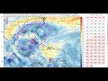 Marco to Make Landfall Monday; Laura a Dangerous Threat to Greater Antilles and Northwest Gulf Coast
 HURRICANE UPDATE - Hurricane MARCO Drops in Pressure Tropical Storm LAURA Smashes Haiti Evacuations
 NHC Director: Louisiana not out of the woods after Marco track shift
 Tropical Storm Laura Update August 23 2020 - Hazard Management Cayman Islands.
 TROPICAL UPDATE TEXAS BE AWARE
 Marco and Laura expected to hit U.S. as Hurricanes- Sun Morning Update
 Tropical update, August 23, 2020
 TROPICAL UPDATE DOUBLE TROUBLE NOT LOOKING GOOD
 4 PM UPDATE: Marco becomes category 1 hurricane south of Lafayette
 Hurricane Forecast Discussion - Major Hurricane Laura Looking Still Possible
 Tropical Storm Laura lashes Caguas, Puerto Rico
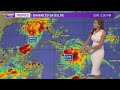 Sunday evening tropical update on Marco as it nears the Louisiana coast, plus Laura farther out
 Sunday Morning Weather Forecast With Darren Peck
 What can we expect in South Florida from Tropical Storm Laura?
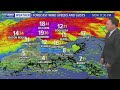 Sunday 5 pm Hurricane Marco and Tropical Storm Laura update
 J7409 Weather Tropical SEVERE & General
 Videocast: Marco Approaches Gulf Coast
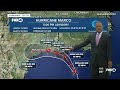 Tropics Update 8/23/20 Sun. PM