Using Open Source LiDAR for Archaeology
A recording of a workshop given by Dr Edward Peveler on 30/6/2020 showing you how to download and process open source LiDAR data, using open source tools, in order to better visualise archaeological features in the landscape.
The powerpoint can be downloaded here: https://bit.ly/2VFd0if
This workshop was run as part of the National Lottery Heritage Fund funded Beacons of the Past Project, based at the Chilterns Conservation Board.
https://chilternsbeacons.org/wp/
https://www.chilternsaonb.org/projects/beacons-of-the-past.html
This work flow uses QGIS: https://www.qgis.org/en/site/forusers/download.html
Relief Visualisation Toolbox: https://iaps.zrc-sazu.si/en/rvt#v
Data from the Environment Agency:
https://environment.data.gov.uk/DefraDataDownload/?Mode=survey
Видео Using Open Source LiDAR for Archaeology канала Chilterns Conservation Board
Показать
Комментарии отсутствуют
Информация о видео
1 июля 2020 г. 17:56:29
00:40:28
Другие видео канала
 Approaches to LiDAR Visualisation for Archaeology
 Paleoindian Excavation at Jackson Gore Vermont
 “The Future of Archaeology: Space-based Approaches” Sarah Parcak ’01
 Topographic Profiles from LIDAR data in QGIS
 How to create base map in AUTOCAD using QGIS and data from AURIN and VICMAP
 Using Lidar for Archaeological Research
 Making Sense of Funerary Monuments and Funerary Practices
 Contribution of UAV LiDAR to Archeology (LiDAR for Drone 2019)
 Native American History Of Massachusetts - Episode 1
 Whither Roman Scotland?
 Getting started with free, open LiDAR data
 4 Awesome Discoveries made with LIDAR Technology
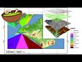 Aspects of Archaeology: G.I.S.
 QGIS Buffering - Part 1
 Finding America - Seeking New Paleolithic Paradigms
 How Does LiDAR Remote Sensing Work? Light Detection and Ranging
 Aspects of Archaeology: Drones
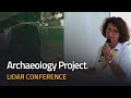 Uncovering a Hill Fort under Vegetation with UAV LiDAR (LiDAR for Drone 2017)
 Build Your Own LIDAR Images With Qgis
 HOW TO USE LIDAR MAPS