Finally Understanding Class G and E Airspace Using 3D Modeling
The alternative title for this video could be "Airspace Hurts My Head". LOL! As a student pilot seeking my Private Pilot Certificate, I believe that having a solid understanding of airspace is important. Questions about airspace are guaranteed to come up during the written exam, and probably just as guaranteed to come up during the check ride.
I made this video not for you. I made it for me. Okay, maybe a little bit for you, if you need some help in this area.;-) However, the reality of it is that I learn so much myself from trying to put something like this together. I really have to understand what I am talking about in a way to make enough sense to explain it to someone else.
Understanding Class G and Class E airspace was a challenge for me. It took a lot of research and study before it finally clicked. Class G airspace is practically everywhere, but it rarely shows up on the aviation charts. So how do you find it, and how do you know where it ends? Well...you have to understand Class E airspace for that! The floor of Class E airspace will tell you where the ceiling of Class G is. For the most part, barring specific documented exceptions to this and also barring locations where other airspace is involved, Class G airspace goes from the surface (AKA Ground) to the floor of Class E. Of course, the floor of Class E varies all over the map, and that's hopefully where this 3D model will help visualize things. And yes, there are places of "unobstructed" Class G airspace where it goes from the surface all the way up to the maximum Class G limit of 14,500 MSL. While there are some places that Class G extends to an specific altitude based on other factors (like terrain), the majority of Class G goes from the Surface to either 700 AGL or 1200 AGL.
Another interesting tidbit about Class G and Class E: The floor of Class E and the ceiling of Class G are identified in feet Above Ground Level (AGL) -- except where Class G maxes or where it's otherwise noted. Most all of the other airspace floor and ceiling values are noted in Mean Sea Level (MSL). So just make sure you are paying attention to that. Mostly, when talking about Class G and E, you're talking AGL -- not what your altimeter says (unless you are at sea level, of course ;-)
So while this video mostly focuses on...yep...Class E and Class G, there is a bit about Class B, Class D, and even at least via the model, a look at the Washington FRZ.
I'm not a professional 3D modeler, I am not a CFI, and I'm not selling ground school courses or videos. This content is worth at least what you paid for it. If you don't like it, you can get a full refund. :-) I will say I ran it past several pilots, and a few CFIs before I posted it because I want it to be accurate. It may not be the best presentation, it may not have everything there is to know about this topic, but I didn't want anything in there that was just outright wrong. If you notice something we overlooked, please let me know. If you like it, let me know. I invested many hours into this...so I am hopeful it was helpful for at least one of you. If you really like it, feel free to share it!
Video is 12 minutes long. First 6 is background, and some foundational information that sets up the model demonstration. Last 6 minutes is showing the model and how the airspace is laid out here where I am.
Видео Finally Understanding Class G and E Airspace Using 3D Modeling канала CPO :: A Pilot in Training
Показать
Комментарии отсутствуют
Информация о видео
Другие видео канала
 Airspace Class E and G Explained
 UNDERSTANDING AIRSPACE
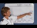 National Airspace System (Private Pilot Lesson 3a)
 Ep. 36: Class E Airspace | Rules and Where it Is
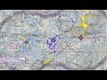 Uncontrolled Airport Information - Sectional Chart
 Class G Airspace ( EVERYBODY STRUGGLES WITH THIS ONE ) Online Ground School
 Airspace Memory Aid
 VFR Sectional Chart Practice Quiz - Remote Pilot 101
 Ep. 34: How to read a VFR Sectional Chart | Basic Chart/Map Knowledge
 Class E and G Airspace
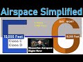 How to Memorize Airspace in 5 minutes.
 Class E Airspace - Where The Heck Does It Start?
 I Passed the FAA Part 107 AKT Test! My tips to help you pass uas drone
 Class D Traffic Pattern - Radio Communications
 Class C Airspace Defined
 Session 5 Sample - Airspace
 Airspace Explained With Minecraft!
 Ep. 44: Landing at Class C Airport | ATC Radio Communications
 Private Checkride
 Ep. 35: Class G Airspace | Where it is and How it Works