Uncontrolled Airport Information - Sectional Chart
** More great content at www.klaviation.com **
Most airports in the United States don't have a control tower. Looking at the FAA Sectional there are hundreds of airports and knowing what services are available and what to expect when you get to the airport is important.
First, we can tell whether the airport has a control tower or not, just by looking at the symbol. A magenta symbol indicates that an airport is non-towered, while a blue symbol indicates a tower. For this lesson we are only interested in the non-towered, magenta airports.
When figuring out if the airport is suitable for us to use, the first thing to look at is runway length. An airport with a solid circle and runway depictions inside indicates the longest runway is 1500-8069 feet long. An airport diagram that looks like a runway without a circle around it means that the longest runway is longer than 8069 feet.
Tick marks around the diagram indicate fuel services and other services are available from at least 10:00am to 4:00pm Monday-Friday. A star at the top of the diagram indicates a rotating beacon.
All other airport information is listed next to the diagram. This includes the airport name, identifier, weather frequency, elevation, longest runway length, CTAF frequency, and other notes.
While you can get almost everything you need just from the diagram, it is also important to check the airport/facility directory before you go. This will give you any other local information you need to know.
Видео Uncontrolled Airport Information - Sectional Chart канала Will Liebhaber
Показать
Комментарии отсутствуют
Информация о видео
Другие видео канала
 FAA Part 107 | Understanding Latitude and Longitude
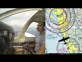 Ep. 44: Landing at Class C Airport | ATC Radio Communications
 Towered Airport Diagram - Sectional Chart
 Airspace Class E and G Explained
 7 Special Use Airspace.avi
 Ep. 36: Class E Airspace | Rules and Where it Is
 Airport Lighting and Signage
 Understanding Airspace For The FAA Part 107 Knowledge Test - Remote Pilot 101
 Free FAA Part 107 Drone Test Study Guide - Answers and Explanations
 VFR Sectional Chart Tips and Example Examiner Questions
 VOR Symbol on the VFR Sectional Chart
 3 Sectional Chart Symbols You Should Know - Remote Pilot 101
 Class C Airspace Defined
 Session 5 Sample - Airspace
 UNDERSTANDING AIRSPACE
 FAA Airspace for VFR FLight
 Maximum Elevation Figure (MEF) - Sectional Chart
 EAA Webinar- Using VFR Sectional Charts
 Lesson #3 - Aeronautical Sectional Charts - FAA Part 107 Remote Pilot Exam