Best Practices for Minimizing Errors during GNSS Data Collection
Aimed at surveyors and GIS professionals who use geodetic-quality GNSS equipment to determine positions for land planning, coastal monitoring and other purposes, this video covers best practices for reducing errors in the areas of: 1. location and environment, 2. equipment setup and 3. observation times and accuracy checks.
For more information on geospatial infrastructure, visit http://www.geodesy.noaa.gov/.
For more information and a gallery of reusable resources from this video see https://www.meted.ucar.edu/training_module.php?id=1197
See COMET's MetEd website for hundreds of other geo-science training resources: http://www.meted.ucar.edu.
Видео Best Practices for Minimizing Errors during GNSS Data Collection канала The COMET Program/MetEd
Показать
Комментарии отсутствуют
Информация о видео
Другие видео канала
 GPS RTK Surveying Workshop
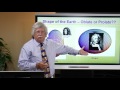 Geodetic Surfaces and Datums
 Training video for SinoGNSS T300 plus GNSS Receiver - Internal Radio Mode
 Reach RS2: Placing The Base Over a Known Point
 Set up total station over a point
 Coordinate System Jargon: geoid, datum, projection
 Precision and Accuracy in Geodetic Surveying
 Leica GS18 T – World’s fastest GNSS RTK rover
 NOAA’s VDatum: Transforming Heights between Vertical Datums
 5 Minute Modules - NTRIP, RTK and Base Stations
 What are Geodetic Datums?
 Different Methods of Setting up the RTK Base
 How Were Geodetic Datums Established?
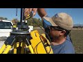 How to setup and use Trimble R10 survey unit
 GNSS RTK Overview Workshop
 Real Time Kinematic (RTK) Surveying
 TOPOGRAPHY and SURVEYING WITH GNSS
 eBee RTK - The Survey-Grade Mapping Drone
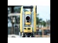 Active Tracking on a Trimble S5 Robot
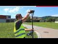 How to use the Leica GS18 T GNSS RTK rover