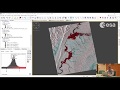
Sentinel-1 flood mapping with SNAP
This video shows workflow for simple mapping of flood coverage using GRD Sentinel-1 data. Video was made based on recipe found at http://asf.alaska.edu
Subscribe: https://youtube.com/c/PrzemysławSlesiński?sub_confirmation=1
#floodmapping #remotesensing #sentinel
Видео Sentinel-1 flood mapping with SNAP канала MrGIS
Subscribe: https://youtube.com/c/PrzemysławSlesiński?sub_confirmation=1
#floodmapping #remotesensing #sentinel
Видео Sentinel-1 flood mapping with SNAP канала MrGIS
Показать
Комментарии отсутствуют
Информация о видео
Другие видео канала
 ESA Echoes in Space - Hazard: Flood mapping with Sentinel-1
 NASA | Peeling Back Landsat's Layers of Data
 RUS webinar: Rapid Landslide Detection with Sentinel-1 - HAZA07
 NASA ARSET: SAR for Flood Mapping Using Google Earth Engine, Part 1/3
 ESA Echoes in Space - Hazard: Volcanic eruption mapping with Sentinel-1
 RUS Webinar: Oil spill mapping with Sentinel-1 - OCEA03
 Sentinel-1 GRD processing workflow in SNAP
 NASA ARSET: Monitoring Flood Extent with Google Earth Engine, Part 1/2
 Download and Extract Soil Moisture Data from Sentinel 1 and SMAP using ArcGIS Desktop
 Sentinel-1 glacier movement velocity map in SNAP
 Extract Urban Built Up Area Footprint from SAR Data Using ESA SNAP. Part 2 Coherence Analysis
 Flood mapping
 PSI using SNAP-STAMPS platform in WSL part 1
 RUS Webinar: Flood Mapping with Sentinel-1 - HAZA01
 ESA Echoes in Space - Water: Water Body Mapping with Sentinel-1
 ESA Echoes in Space - Land: Crop type mapping with Sentinel-1
 ESA Echoes in Space - Geometry: Introduction to SNAP
 Introduction to Sentinel-1 visualisation in Earth Engine - Lab 8
 Lesson 9.1 Satellite images. Spectral Signatures. Band combination. Sentinel 2.
 ESA Echoes in Space - Land: Urban Footprint mapping with Sentinel-1