AI for Earth’s Land Cover Mapping
High-resolution land cover mapping is a process of assigning land use labels, such as “impervious surface,” or “tree canopy” to each pixel in high resolution (<1m) aerial or satellite imagery. Such maps are an essential component in environmental science, agriculture, forestry, urban development, the insurance and banking industries, and for demography in developing countries.
Traditional Geographic Information System (GIS) workflows start with a variety of segmentation and classification algorithms and involve specialized human labor that refines these initial maps. Open street maps and other crowdsourcing platforms, on the other hand, utilize work of thousands of volunteers through mapping runs in which land cover maps are created from scratch. Both approaches are labor-intensive and this can dissuade agencies and researchers from pursuing some studies, especially the ones that track the land use longitudinally at high temporal rates. And so, with the optimism over modern deep learning and reinforcment/active learning came renewed interest within ML and computer vision communities in these applications, which involve terabytes of mostly unlabeled or weakly/indirectly labeled data. I will talk about several approaches to rapid land cover mapping we have investigated on our road to creating the first ever 1m resolution land cover map of the entire USA. These approaches involve novel deep learning models that can super-resolve low res labels, active learning, machine teaching and hybrid intelligence. I will also discuss exciting opportunities both to develop new machine learning models or hybrid systems, and to make practical impact.
See more at https://www.microsoft.com/en-us/research/video/ai-for-earths-land-cover-mapping/
Видео AI for Earth’s Land Cover Mapping канала Microsoft Research
Показать
Комментарии отсутствуют
Информация о видео
Другие видео канала
 Fighting extinction with Microsoft AI and citizen science
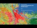 NASA ARSET: Introduction to Land Cover Classification and QGIS, Part 1/2
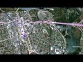 GIS: Mapping your World
 Hanna Meyer: "Machine-learning based modelling of spatial and spatio-temporal data" (practical)
 The Real Reason to be Afraid of Artificial Intelligence | Peter Haas | TEDxDirigo
 Interview With The Lifelike Hot Robot Named Sophia (Full) | CNBC
 How to FLY A SPACESHIP to the SPACE STATION - Smarter Every Day 131
 Quantum-Systems #TrinityF90+ mapping a golf course for VR Data
 OceanMind is using Microsoft AI to fight illegal fishing
 22 Inventions That Are Saving The Earth
 Artificial Intelligence, the History and Future - with Chris Bishop
 Tutorial: Land Cover Classification and Mosaic of Several Landsat images
 Machine Learning, Artificial Intelligence and ArcGIS
 AI Codes its Own ‘AI Child’ - Artificial Intelligence breakthrough!
 Understanding Artificial Intelligence and Its Future | Neil Nie | TEDxDeerfield
 The Wasserstein Metric a.k.a Earth Mover's Distance: A Quick and Convenient Introduction
 This Farm of the Future Uses No Soil and 95% Less Water
 11. Introduction to Machine Learning
 How Will Artificial Intelligence Affect Your Life | Jeff Dean | TEDxLA