Sentinel-6 Launch Animation
Designed to measure the height of the ocean - a key component to understanding how Earth's climate is changing - Sentinel-6/Jason CS consists of two identical satellites that will be launched five years apart. The staggered launches will help to ensure the continuation of a decades-long record of sea level observations out to 2030.
A secondary objective of the mission will be to measure temperature and humidity in the troposphere, the atmospheric layer in which we live. The satellites will also look at the stratosphere, the layer right above the troposphere. An instrument on board the satellites uses the Global Navigation Satellite System Radio-Occultation sounding technique, which analyses changes in signals from international global navigation system satellites to determine atmospheric temperature and humidity.
NASA is developing the mission with the European Space Agency, the European Organisation for the Exploitation of Meteorological Satellites, and the National Oceanic and Atmospheric Administration. The European Commission is providing funding support. France's space agency, the Centre National d'Etudes Spatiales, is also supporting the mission.
Scientific Instrument(s)
- Poseidon-4 SAR Radar Altimeter
- Advanced microwave radiometer for Climate (AMR-C)
- Global Navigation Satellite System - Radio Occultation (GNSS-RO)
- Doppler Orbitography and Radiopositioning Integrated by Satellite (DORIS)
- Laser Retroreflector Array (LRA)
#sentinel6
#nasa
#spacex
Видео Sentinel-6 Launch Animation канала Space Snack
Показать
Комментарии отсутствуют
Информация о видео
Другие видео канала
 SpaceX Falcon 9 Launch (Anaheim, Ca)
 If Rockets were Transparent
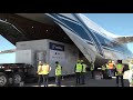 Sentinel 6 Arrives at Vandenberg for SpaceX Launch
 Mars Science Laboratory Curiosity Rover Animation
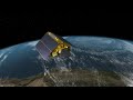 Sentinel 6 Animation Reel
 NASA's Shuttle-Derived Heavy Lift Launch Vehicle Concept
 STS-134 - The final launch of Endeavour - Full Launch in HD
 SpaceX Crew-1: Earth From Space seen from Crew Dragon Arrival at Space Station | ISS Docking
 We Are Going
 How We Are Going to the Moon - 4K
 STS-133 The Final Launch of Space Shuttle Discovery including T-5 hold
 Sentinel 6 entra em órbita este fim de semana
![NASA Mars Science Laboratory (Curiosity Rover) Mission Animation [HDx1280]](https://i.ytimg.com/vi/gwinFP8_qIM/default.jpg) NASA Mars Science Laboratory (Curiosity Rover) Mission Animation [HDx1280]
NASA Mars Science Laboratory (Curiosity Rover) Mission Animation [HDx1280] SpaceX Falcon Heavy- Elon Musk's Engineering Masterpiece
 SpaceX Falcon 9 Rocket Launch & Landing | NASA Sentinel-6 Michael Freilich Mission | Replay
 Sentinel-6: charting sea level
 How NASA, SpaceX, And Blue Origin's Monster Rockets Compare
 Launch of Sentinel-6 Michael Freilich Satellite
 Copernicus Sentinel-6 measuring sea levels using radar altimetry
 Blastoff! SpaceX launches Sentinel-6 satellite from California