Sentinel-6: charting sea level
In a cleanroom in Ottobrunn, Germany, the latest Copernicus Sentinel satellite is ready for final testing before it is packed up and shipped to the US for liftoff next year. Designed and built to chart changing sea level, it is the first of two identical Sentinel-6 satellites that will be launched consecutively to continue the time series of sea-level measurements. This new mission builds on heritage from previous ocean topography satellites, including the French–US Topex-Poseidon and Jason missions, previous ESA missions such as the ERS satellites, Envisat and CryoSat, as well as Copernicus Sentinel-3. With millions of people around the world at risk from rising seas, it is essential to continue measuring the changing height of the sea surface so that decision-makers are equipped to take appropriate mitigating action – as is being currently highlighted at the COP-25 Climate Change Conference in Spain.
Learn more about Sentinel-6: http://bit.ly/Sentinel6
★ Subscribe: http://bit.ly/ESAsubscribe and click twice on the bell button to receive our notifications.
Check out our full video catalog: http://bit.ly/SpaceInVideos
Follow us on Twitter: http://bit.ly/ESAonTwitter
On Facebook: http://bit.ly/ESAonFacebook
On Instagram: http://bit.ly/ESAonInstagram
On Flickr: http://bit.ly/ESAonFlickr
We are Europe's gateway to space. Our mission is to shape the development of Europe's space capability and ensure that investment in space continues to deliver benefits to the citizens of Europe and the world. Check out http://www.esa.int/ESA to get up to speed on everything space related.
Copyright information about our videos is available here: http://www.esa.int/spaceinvideos/Terms_and_Conditions
#ESA
#EarthObservation
#Sentinel6
Видео Sentinel-6: charting sea level канала European Space Agency, ESA
Показать
Комментарии отсутствуют
Информация о видео
5 декабря 2019 г. 23:34:11
00:05:32
Другие видео канала
 How to access Copernicus Altimetry data
 IN SPACE WITH ESA: Copernicus Sentinel-6 measuring sea-levels using radar altimetry
 Meet the Satellite: Sentinel-3
 Jason-3 Hosted Webcast
 Mission Minerva meets Cosmic Kiss | Two astronauts in orbit
 This is what sea level rise will do to coastal cities
 Earth from Space: Arc de Triomphe, Paris
 NASA Science Live: Rising Seas
 How to Calculate the Enhanced Vegetation Index (EVI) with Sentinel-2 Satellite Imagery
 What is the Copernicus Programme?
 Is sea level rising?: Benjamin P. Horton at TEDxNavesink
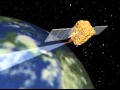 NASA Now: Orbital Mechanics: Earth Observing Satellites
 Soyuz MS-10 launch failure
 New projections for sea-level rise due to climate change
 Could rising waters submerge the state of Florida?
 Gaia's 3D View of Our Galaxy
 Lake Mead Drone Footage
 Falcon 9 launch (w/ sonic boom) from Vandenberg AFB carrying Sentinel-6 Michael Freilich satellite
 Meet NASA's Severine Fournier, Sentinel-6 Michael Freilich Sea Level Rise Scientist — Live Q&A