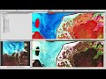
NDVI from Sentinel-2 in SNAP
Guided tutorial explaining how to derive NDVI from Sentinel-2 imagery in the ESA Sentinel Application Platform (SNAP)
Assoc. Prof. Shaun R Levick
https://www.geospatialecology.com
Видео NDVI from Sentinel-2 in SNAP канала GEARS - Geospatial Ecology and Remote Sensing
Assoc. Prof. Shaun R Levick
https://www.geospatialecology.com
Видео NDVI from Sentinel-2 in SNAP канала GEARS - Geospatial Ecology and Remote Sensing
Показать
Комментарии отсутствуют
Информация о видео
22 марта 2018 г. 7:06:00
00:17:56
Другие видео канала
 Exploring Sentinel-2 multi-spectral band combinations in SNAP
 Calculate NDVI from Sentinel 2 and reclassify in QGIS
 ESA Echoes in Space - Hazard: Flood mapping with Sentinel-1
 RUS webinar: Vegetation monitoring for Agriculture with Sentinel-2 - LAND11
 NDVI & PRI Measurement Theory, Methods, and Applications
 SNAP - Calculate Normalized Difference Vegetation Index (NDVI)
 Land Cover Classification using the Semi-Automatic Classification Plugin version 7
 RUS Webinar: Crop mapping with Sentinel-2 - LAND01
 ESA Echoes in Space - Geometry: Introduction to SNAP
 How to Visualise Sentinel 3 Data
 PSI using SNAP-STAMPS platform in WSL part 1
 Classification Part 3 - Supervised classification
 Environmental Monitoring 2019 - Lab 1
 mosaicing, subsetting and masking raster datasets in SNAP
 ESA Echoes in Space - Water: Water Body Mapping with Sentinel-1
 RUS webinar: Freshwater Quality Monitoring with Sentinel-2 - HYDR02
 How to access Copernicus ocean colour data
 Atmospheric Rayleigh Scattering Correction of Sentinel 2 Imagery using ESA SNAP
 SNAP - Mosaicing
 Introduction to Remote Sensing of the Environment - Lab 1