Flood inundation area mapping using Global Mapper
This video shows how to determine flood extent area due to the rise of water level
#Flood_Inundation
#Global_Mapper
#Mamema_Tube
Видео Flood inundation area mapping using Global Mapper канала Mamema Tube
#Flood_Inundation
#Global_Mapper
#Mamema_Tube
Видео Flood inundation area mapping using Global Mapper канала Mamema Tube
Показать
Комментарии отсутствуют
Информация о видео
Другие видео канала
 Great Ethiopian Renaissance Dam (GERD)/ታላቁ የ ኢትህዮጵያ ህዳሴ ግድብ
 Analytical Hierarchy Process (AHP) using ArcGIS
 How to use Google Earth for preliminary Pipe network layout
 LiDAR Editing and Filtering in Global Mapper
 How to calculate the volume of reservoir of Dam using ArcGIS
 Raster Processing in Global Mapper
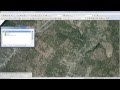 UAV Data Processing in Global Mapper
 Blue Nile River in Ethiopia/ Abay Canyon
 Analyzing Terrain in Global Mapper
 Watershed analysis with Global Mapper
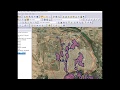 Flooding analysis, work flow with Global Mapper
 What's New in Global Mapper v.18
 Automatic Extraction of Sub-Watershed using Global Mapper
 What's New in Global Mapper v21
 Using GPS with Global Mapper
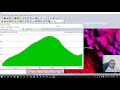 How to extract profile from Global Mapper
 How to Export data from WaterGEMS to CAD and GIS
 Calculate Volume of Reservoir using ArcGIS
 Top 10 Global Mapper Features
 Raster Processing and Analysis in Global Mapper