Mount St. Helens 2004-2008 Eruption: A Volcano Reawakens
http://gallery.usgs.gov/videos/835
Mount St. Helens reawakened in late September 2004. Small magnitude earthquakes beneath the 1980-1986 lava dome increased in frequency and size, and a growing welt formed on the southeast margin of the previous lava dome and nearby portions of Crater Glacier. On October 1, 2004, the first of several explosions shot a plume of volcanic ash and gases from a vent on the growing welt, followed by the slow extrusion of lava. For the next three years, a series of hot, solid, smooth-sided lava spines rose from the vent, bulldozed their way across the crater floor and piled up to form a new dome 460 m (1,500 ft) high. The growing lava dome pushed Crater Glacier aside, causing it to flow rapidly toward the front of the 1980 breach; flow continues today.
Scientists used a variety of monitoring techniques during the 2004-2008 eruption, such as tracking ground deformation, measuring the temperature of lava spines, interpreting earthquakes, sampling groundwater, observing changes to water quality, deploying temporary remote monitoring stations (spiders), collecting and analyzing lava samples, producing time-lapse videos of dome growth and glacier advance, and digital elevation models of surficial changes in the crater. By monitoring Mount St. Helens, scientists are better able to understand the volcano’s behavior, to assess hazards and potential impacts, and to provide timely warnings of future events.
The video was produced for a public event commemorating the 10th anniversary of the beginning of the 2004-2008 eruption.
Видео Mount St. Helens 2004-2008 Eruption: A Volcano Reawakens канала USGS
Показать
Комментарии отсутствуют
Информация о видео
Другие видео канала
 Time-lapse images of Mount St. Helens dome growth 2004-2008
 October 1, 2004 Explosion at Mount St. Helens
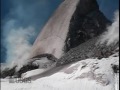 Mount St. Helens: Instrumentation and Dome Growth, April-May 2006
 Mount St. Helens eruption highlights: September 2004 - May 2005
 Mount St. Helens' Runaway Glacier: A time-lapse video of Crater Glacier
 Mount St. Helens: May 18, 1980
 Caldera Demonstration Model
 Mount St. Helens: A Catalyst for Change
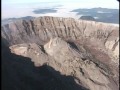 Mount St. Helens: Instrumentation and Dome Growth, May-Sept 2006
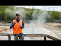 Monthly update of activity at Yellowstone Volcano for June 2021
 Lees Ferry - 100 Years of Streamflow Monitoring
 The 20th Century's Greatest Volcanic Eruption: Mt Katmai 100 Years Later
 Image of the Week - Fires Worldwide as Seen by Landsat 8
 HLS: Magnum Fire, Arizona
 Mount St. Helens--Lives Changed, Lessons Learned, and Legacies of the 1980 eruption
 Yellowstone Volcano Update for August 2021
 Earth Observation User Case Study: Nikki Tulley - Speaking a New Language of Landsat
 Reducing Flood Risks by Restoring Coral Reefs
 Utah landslides - Types, problems and risk reduction - Landslide Hazards Program Seminar Series