Image of the Week - Fires Worldwide as Seen by Landsat 8
Landsat satellites acquire useful data on wildfires around the world. Their near infrared and shortwave infrared imaging allows for detection and mapping of fire, smoke, and burn scars often in remote areas.
In California: the Dixie Fire near Lake Almanor and the Caldor Fire near Lake Tahoe.
In Israel: over 6,000 acres in the Jerusalem Hills just west of Jerusalem.
In Canada: active fire just west of Lake Winnipeg and a large burn scar from earlier in the summer.
In Russia: numerous fires and burn scars in the Siberian region.
In Greece: more than five times the yearly average of fire activity.
Video: https://www.usgs.gov/media/videos/image-week-fires-worldwide-seen-landsat-8
Видео Image of the Week - Fires Worldwide as Seen by Landsat 8 канала USGS
Показать
Комментарии отсутствуют
Информация о видео
Другие видео канала
 Mudpot at Artists' Paintpots — Sounds of Yellowstone (ASMR, Sleep, Concentration)
 Cinnamon Spouter — Sounds of Yellowstone (ASMR, Sleep, Concentration)
 Kīlauea Volcano, Hawaii (Halemaʻumaʻu crater)
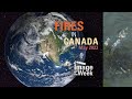 Image of the Week: Fires in Canada, May 2023
 June 18, 2023 — Video of southwest wall vent in Halemaʻumaʻu
 June 7, 2023 — Video of eruption onset in Halemaʻumaʻu
 National Ocean Month: 10 Ocean Field Sites You’ve Got to “Sea” to Believe
 June 12, 2023 — Aerial video of Kīlauea summit eruption
 Halemaʻumaʻu eruption sampling - June 7, 2023
 HVO moves B1cam away from eruption in Halema‘uma‘u crater, Kīlauea volcano — June 8, 2023
 Timelapse of Halema‘uma‘u eruption, Kīlauea volcano — June 7-9, 2023
 Vent that formed on the wall of Halema‘uma‘u crater, Kīlauea volcano — June 7, 2023
 Vigorous lava fountaining from new vents in Halema‘uma‘u, Kīlauea volcano — June 7, 2023
 Video of vortex in Halema‘uma‘u crater, Kīlauea summit eruption - June 7, 2023
 V1cam captures Kīlauea summit eruption onset in Halema‘uma‘u - June 7, 2023
 Flying Over Valles Marineris, Mars with Analysis-Ready Data
 Kīlauea summit eruption overflight — June 8, 2023
 Kīlauea eruption overflight video - June 7, 2023
 Kīlauea summit whirlwind in Halema‘uma‘u - June 7, 2023
 Aerial video of Kīlauea summit eruption in Halema‘uma‘u - June 7, 2023
 Yellowstone Volcano Update — June 2023 (Old Faithful doesn't always empty)