Mineral Mapping and Classification Using Spectral Information Divergence in ENVI 5.7
To collect mineral spectral information, conduct experiments and collect spectroscopy ground reference measurements. Unload equipment carefully, especially the fragile spectroradiometer, and mount it in a backpack with a reference panel, a laptop for control, and a rod to hold the fiber optic cable. Wear dark clothes to avoid spectral contamination. Adjust the integration time using a reference panel, measure dark current, and perform a reference measurement before the actual spectral measurement. Walk into the field, avoiding damage to minerals, and point the spectrometer to predefined GPS coordinates, continuously recording and averaging spectra.
To classify an image using Spectral Information Divergence (SID), first, select a set of reference spectra (endmembers) representing the pure spectral signatures of minerals in the scene. Calculate the spectral angle between each pixel's spectrum and the reference spectra, treating them as vectors in a space with dimensions equal to the number of spectral bands. Pixels with angles smaller than a specified threshold are classified as the closest spectral match to the reference spectrum. Pixels with angles larger than the threshold are not classified. This method is robust in different lighting conditions and provides valuable information for mineral identification and mapping in hyperspectral imagery.
Видео Mineral Mapping and Classification Using Spectral Information Divergence in ENVI 5.7 канала Space, Remote sensing and GIS
Показать
Комментарии отсутствуют
Информация о видео
23 марта 2024 г. 12:43:25
00:07:32
Другие видео канала
 Forest fire assessment using indices and change detection tool in ArcGIS Pro
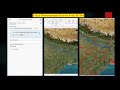 How to trace downstream in ArcGIS Pro
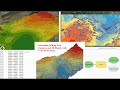 UTM excel DGPS data conversion for mining
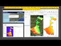 Download Rainfall Data Hourly, Daily, Monthly, Yearly, Data Processing & Map Preparation in ArcGISPr
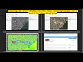 Exploring Historical High-Resolution Images with ArcGIS Pro: Identifying Changes in Varanasi City
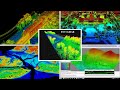 ENVI LIDAR
 River Stream Order Map in ArcGIS Pro
 Use Neighborhood Explorer tool in ArcGIS Pro
 Download Water body data (Shapefile) Lakes, River, Wetland of any Location and open it in ArcGIS Pro
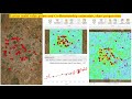 Extract multi value points and Co Relationship estimation, chart preparation
 Watershed/ catchment extraction in ArcGIS Pro
 ACE Target Detection over Hyperspectral Data
 ENVI Crop science tool for precision agriculture
 NDVI with ArcPy for Python Developers using ArcGIS Pro
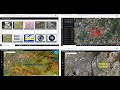 ESRI imagery web-apps and use Sentinel-2 and Landsat Imagery with ArcGIS Pro
 Captivating Image of Cyclone Biparjoy Reveals Unprecedented Details: Download and Analyze
 Roop kund Trek base point video created using ArcGIS Pro Animation tool
 Extract Elevation Values from DEM
 Direction and Distance for urban expansion in ArcGIS Pro
 Cloud removal in satellite image
 Creating 3D Sea Level Rise Maps with ArcGIS Pro: A Visual Exploration part 1