Sentinel2 images exploration and processing with Python and Rasterio - Tutorial
Rasterio is a Python library that allows to read, inspect, visualize and write geospatial raster data. The library uses GeoTIFF and other spatial raster formats and is capable of working with satellite imagery, digital elevation models, and drone imagery data products. Rasterio allows you to import a single band or multiband geospatial raster in a interactive Python enviroment as Jupyter notebook, the library can keep the “duality” of the geospatial raster, that means, it can handle the location and resolution parameters as well as the matrix values of the gridded elements.
This tutorial shows some basic procedures to explore a multiband Sentinel 2 granule with Python 3 and Rasterio on a Jupyter Notebook. The tutorial shows the comands to identify the raster array dimensions and the geospatial referencing parameters, make representation of each visible band and export band composites as true color and false color geoespatial rasters in Tiff format.
Input data
You can download the input data and scripts for this tutorial here:
https://www.hatarilabs.com/ih-en/sentinel2-images-explotarion-and-processing-with-python-and-rasterio
Видео Sentinel2 images exploration and processing with Python and Rasterio - Tutorial канала Hatari Labs
Показать
Комментарии отсутствуют
Информация о видео
Другие видео канала
 RUS webinar: Processing Copernicus data in Python using snappy - PY01
 Introduction to Geospatial Data Analysis with Python | SciPy 2018 Tutorial | Serge Rey
 Unsupervised Classification of a satellite image using ArcGIS
 Instance Segmentation MASK R-CNN | with Python and Opencv
 Rasterio for absolutely beginner | Geospatial data analysis with python | GeoDev
 228 - Semantic segmentation of aerial (satellite) imagery using U-net
 Supervised Classification with Sentinel 2 Satellite Images | Google Earth Engine | Machine Learning
 Python HOW TO structure a Beginner OR Advanced Projects ?
 R for Basic Image Processing Part 1| Remote Sensing|Landsat
 Webinar: eo-learn basics
 Satellite Image Mosaicing using Python and Jupyter Notebook
 201 - Working with geotiff files using rasterio in python (also quick demo of NDVI calculation)
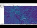 Python GIS - NDVI From Landsat Satellite Image (GDAL)
 Image Processing Using Python | Convolutional Neural Network For Image Processing | Great Learning
 Remote sensing with Python in Jupyter | burdGIS
 NDVI calculation from Landsat8 images with Python 3 and Rasterio - Tutorial
 Hands-on Satellite Imagery Analysis | Scipy 2019 Tutorial | Samapriya Roy, Sara Safavi
 Study Area extraction from Google Earth and Export in ArcMap
 Katherine Scott Python from Space Analyzing Open Satellite Imagery Using the Python Ecosystem