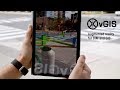
vGIS Exploration - Augmented Reality visualization solution for Oil and Gas exploration
Designed specifically for Oil and Gas companies, vGIS Exploration works in conjunction with your existing Esri ArcGIS back-end to display wellbores, frac stages, micro seismic events, rock formations, extraction and other data in near real-time.
No manual data preparation - Esri GIS data is converted into the holographic visuals by the vGIS engine on the fly.
vGIS exploration uses Microsoft HoloLens hardware and Esri ArcGIS back-end, which means no custom coding, no long implementations and no manual data conversions.
More at http://www.vgis.io.
Видео vGIS Exploration - Augmented Reality visualization solution for Oil and Gas exploration канала vGIS Inc.
Показать
Комментарии отсутствуют
Информация о видео
Другие видео канала
 vGIS - The Most Advanced Augmented Reality System for GIS and BIM
 The most advanced AR system for GIS - vGIS Utilities
 Fundamentals of Upstream Oil and Gas
 Augmented Reality Sandbox will Blow Your Mind!
 Oil and Gas 101 - Typical SOR Instrumentation Applications
 Visualizing Geology in the Field with Augmented Reality
 Oil and gas companies are facing major technological disruption
 Oil Drilling | Oil & Gas Animations
 Make your Own Augmented Reality - with PowerPoint and HP Reveal (Formerly Aurasma))
 HoloLens Plant Investigation and 3D Pipe Design Assistant
 vGIS Lab: objects appear to float in augmented reality (AR)
 A Basic Overview of the Oil & Gas (Energy) Industry
 SPACE1 - Augmented Reality Smart Construction
 11 Best AR Smart Glasses (Augmented Reality Headsets)!
 ORINOX - VR for Process, Energy, Naval Industry
 Tutorial - Creating an Augmented Reality GIS Map Application using Opensource software
 Digital twin: Making your asset smarter with the digital twin
 HoloLens Technology
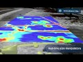 GPR scan visualization with vGIS
 Augmented Reality Visualization Solution for Oil and Gas Exploration