vGIS - The Most Advanced Augmented Reality System for GIS and BIM
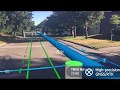
vGIS Utilities (https://www.vgis.io) is the most advanced augmented reality solution for BIM and GIS visualizations. vGIS was designed to create a more productive, enjoyable and safe working environment. The system connects to Esri ArcGIS, Bentley iTwin and other sources to seamlessly convert and aggregate data into powerful, accurate and stable 3D visuals. vGIS Utilities is deployed at over 100 sites across the world to bring real-life benefits to its users.
Видео vGIS - The Most Advanced Augmented Reality System for GIS and BIM канала vGIS Inc.
Видео vGIS - The Most Advanced Augmented Reality System for GIS and BIM канала vGIS Inc.
Показать
Комментарии отсутствуют
Информация о видео
Другие видео канала
 The most advanced AR system for GIS - vGIS Utilities
 GAMMA AR - Construction with Augmented Reality + BIM - On site with PORR
 BIM and GIS: An Introduction
 The Future of Augmented Reality - AR in Healthcare
 The Best Kept Secret in Construction | Michael Johnson | TEDxDavenport
 XR - The Future of VR, AR & MR in One Extended Reality
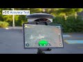 Testing high-accuracy outdoor AR by vGIS Inc.
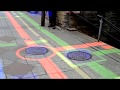 Using the HoloLens for accurate subsurface utility pipes augmented reality
 BIM for Project Managers
 What is BIM and how it is changing the construction industry?
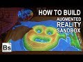 Augmented Reality Sandbox - How to Build the Sandbox
 Virtual Reality (VR) and Augmented Reality (AR) with ArcGIS
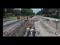 vGIS App - Augmented reality, reality capture and infrastructure
 The Future of Making Buildings | Phil Bernstein | TEDxYale
 5 Best Smart Glasses of 2021
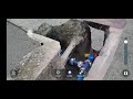 Infrastructure, context capture and augmented reality AR by vGIS
 How Augmented Reality Can Give Us Superpowers | John Werner | TEDxMidAtlantic
 Boaz Ashkenazy: Visualizing Place With VR, AR, & Mixed Reality
 MSA Mixed Reality Operations
 The Tallest Skyscrapers Under Construction in 2019