Mapping Mangrove extent with Sentinel-2 : segmentation classification in SAGA GIS 4+
Mapping Mangrove extent with Sentinel-2 : segmentation classification in SAGA GIS 4+
An example of using free open source data and software for mapping vegetation . This tutorial uses imagery from Northern Sulawesi Indonesia.
Steps:
1. Download Sentinel 2 Imagery
2. Clip to your area of interest
3. Conduct segmentation classification
4. Select mangrove segments (polygons)
5. Edit classification
6. Calculate area
For more SAGA tutorials goto:
https://sagatutorials.wordpress.com/
Видео Mapping Mangrove extent with Sentinel-2 : segmentation classification in SAGA GIS 4+ канала rohan fisher
Показать
Комментарии отсутствуют
Информация о видео
Другие видео канала
 NAFI PLUGIN
 Sentinel 2 -Mexico Mine Mapping. Espanol
 High-resolution fire imagery in QGIS
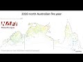 2020 Hotspot animation
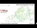 2020 hotspot animation Kimberley
 Central Australia 2011 hotspot animation
 Tree Species Identification Through 3D / Hyperspectral Fusion
 2020 hotspotanim Top-End
 2020 Hotspot Animation Cape York
 Watersheds in the Rio Grande | Story from the Coca-Cola Co.