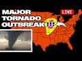
Another Tornado OUTBREAK Likely - S-Tier Chasers on Ground
JOIN TEAM DOMINATOR - https://www.youtube.com/channel/UCV6hWxB0-u_IX7e-h4fEBAw/join
Today's forecast is even more dire than yesterday's. A pronouced midlevel trouch is moving eastward today and will eject northeastward over the central and southern High Plains. The most numerous/intense storms are expected from north Texas into Oklahoma and southeast Kansas, where strong tornadoes, very large hail of 2-3 inches in diameter and damaging winds are very possible. Please please please do not track down our chasers. Have a plan today, stay weather aware and safe. Never Stop Chasing.
TODAY'S 15% HATCHED RISK AREA INCLUDES OKLAHOMA CIT, TULSA, NORMAN, WICHITA FALLS, AND LAWTON
TODAY'S 10% HATCHED RISK AREA INCLUDES DALLAS, FORT WORTH, KANSAS CITY, ARLINGTON, WICHITA
———————————
SHOP REED TIMMER HERE:
https://shopnsc.com/
FOLLOW ON OTHER PLATFORMS, TIP & CONTACT ME HERE:
https://linktr.ee/reedtimmer
-----------------------------------------
Guest Chasers
Edgar - EdgarTheStormchaser.com
Jordan - @StormChaserJordanHall
Sierra - https://x.com/sierra_lindsey3?s=21
Guy in the corner - @brianvotoole
Видео Another Tornado OUTBREAK Likely - S-Tier Chasers on Ground канала Reed Timmer
Показать
Комментарии отсутствуют
Информация о видео
Другие видео канала
 Major Tornado Outbreak from Team Dominator Storm Chasers
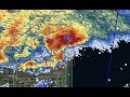 LIVE emergency update with TORNADO WARNING in Fort Lauderdale, FL area
 Top Ten Blizzards Caught on Camera - Last Decade!
 Storm Chase Mode Activated - Next week we chase!
 LIVE severe weather briefing on SUPERCELL threat in southern MICHIGAN into northern INDIANA this eve
 Drone POV of WILD Dixie Alley Tornado & Amazing Shelf Cloud
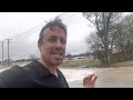 UPDATE on tornado outbreak potential in Texas
 Storm chase mode update from central Mississippi
 EMERGENCY SEVERE WEATHER REPORT! Update on tornado potential today!
 Dixie Alley Chase with Tornado Warned Supercell and Shelf Cloud
 Most Powerful Hurricane Ian storm surge and 150+ mph winds light up the legendary Dominator Fore!
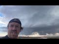 INSANE El Nino ramp up triggers a month of mothership supercells, tornadoes, and flooding!
 UPDATE on mondo ICE STORM tonight-Thursday! Also, sleeper TORNADO setup tomorrow southern MS to AL
 COLORADO WILDFIRE coverage
 LAKE EFFECT SNOW PLUME analysis! Up to 3 FEET of snow downwind of Lake Ontario
 UPDATE on tornado outbreak potential January 1, low-end tornado potential today central AL into GA
 Storm chaser intercepts major flood in Greenville, South Carolina by drone
 HISTORIC & RARE - ThunderSNOW and Lake Effect Storm Buffalo Southtowns
 ENHANCED RISK with tornado potential has been added from southeast AR across northern MS/AL, S TN
 The most INTENSE EYEWALL of Hurricane Nicole - Melbourne Beach Florida
 Update from South Carolina with fast-moving tornado potential by Saturday morning!