- Популярные видео
- Авто
- Видео-блоги
- ДТП, аварии
- Для маленьких
- Еда, напитки
- Животные
- Закон и право
- Знаменитости
- Игры
- Искусство
- Комедии
- Красота, мода
- Кулинария, рецепты
- Люди
- Мото
- Музыка
- Мультфильмы
- Наука, технологии
- Новости
- Образование
- Политика
- Праздники
- Приколы
- Природа
- Происшествия
- Путешествия
- Развлечения
- Ржач
- Семья
- Сериалы
- Спорт
- Стиль жизни
- ТВ передачи
- Танцы
- Технологии
- Товары
- Ужасы
- Фильмы
- Шоу-бизнес
- Юмор
360° Walk to Laser-Grade Point Clouds | Simplifying Scan to BIM Site Capture
Capturing accurate existing conditions doesn’t have to involve complex workflows or specialized scanning crews.
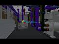
In this session, Chuck Pfeffer, Vice President of Marketing at CUPIX, explains how teams are using simple 360° walkthroughs combined with AI cloud processing to generate measurable 3D point clouds. The result is a full spatial representation of the site that goes far beyond a basic visual tour and supports reliable scan to BIM workflows.
You’ll learn:
- How a simple 360° walkthrough can generate navigable 3D point clouds
- Why spatial context is critical for accurate scan to BIM outcomes
- How AI processing transforms video into usable 3D data
- Ways teams reduce site revisits and improve coordination
This session is ideal for architects, engineers, BIM managers, and AEC decision-makers working with existing buildings.
#ScanToBIM #RealityCapture #AECIndustry #BIM #PointClouds #ConstructionTechnology #DigitalConstruction
Видео 360° Walk to Laser-Grade Point Clouds | Simplifying Scan to BIM Site Capture канала ScantoBIM.Online
Комментарии отсутствуют
Информация о видео
12 февраля 2026 г. 18:56:28
00:00:39
Другие видео канала