- Популярные видео
- Авто
- Видео-блоги
- ДТП, аварии
- Для маленьких
- Еда, напитки
- Животные
- Закон и право
- Знаменитости
- Игры
- Искусство
- Комедии
- Красота, мода
- Кулинария, рецепты
- Люди
- Мото
- Музыка
- Мультфильмы
- Наука, технологии
- Новости
- Образование
- Политика
- Праздники
- Приколы
- Природа
- Происшествия
- Путешествия
- Развлечения
- Ржач
- Семья
- Сериалы
- Спорт
- Стиль жизни
- ТВ передачи
- Танцы
- Технологии
- Товары
- Ужасы
- Фильмы
- Шоу-бизнес
- Юмор
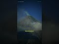
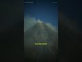
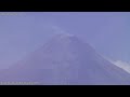
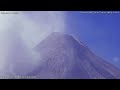
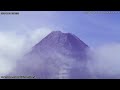
LIVE: [IP Camera] Mayon Volcano, PH (South‑Southwest view)
🔄 STREAM SWITCHER
Stream 3 [IMX-V2cam Summit]: https://youtube.com/live/RWN600ua6qg (Daytime crater view)
Stream 1 [IMX-V1cam]: https://youtube.com/live/dNZEFNG3W8E (Custom bare-metal RasPi camera)
Stream 2 [IP Camera + Auto-IR]: You are watching LIVE here. (Dedicated hardware system utilizing an autonomous IR cut filter for enhanced 24/7 visibility).
🌋 TOPOGRAPHIC TARGET ZONES
• Mi-isi Gully (South): Primary active channel within our optical FOV. High probability zone for routing lava effusion and incandescent rockfalls.
• Bonga Gully (Southeast): Secondary active channel. Frequently tracks pyroclastic and rockfall events visible from the Daraga viewpoint.
• Basud Gully (East): Eastern drainage perimeter. Continuously monitored for flank activity and structural overflow.
Welcome to MayonStream Lab
This is a continuous, real-time autonomous visual monitoring node targeting Mayon Volcano in Albay, Philippines.
What started in 2023 as a bootstrapped hardware experiment has evolved through endless trials and volcanic events into a resilient, 24/7 monitoring station. We are constantly pushing code and upgrading hardware to build a better disaster-monitoring tool for the community. This specific node represents our migration to dedicated IP hardware for seamless day-to-night tracking.
DEPLOYMENT ARCHITECTURE & ROADMAP
[ONLINE] IP Camera: Semi-full FOV equipped with an Auto-IR hardware filter for night vision.
[ONLINE] IMX-V1cam: Mid-range view utilizing a custom-coded Raspberry Pi pipeline.
[IN DEV] IMX-V2cam: Telephoto summit close-up (Hardware in testing).
[PLANNED] Seismic Node: Deploying a low-cost seismic sensor to overlay real-time tremor data directly onto the video feeds.
ETHICAL FOV & PRIVACY
Despite utilizing high-resolution optics, this system is governed by strict privacy constraints. The Field of View (FOV) is mechanically calibrated from our station in Daraga to isolate only the upper slopes and summit crater. We intentionally exclude all residential grids, houses, and barangays from the frame to professionally respect and protect the privacy of our fellow Albayanos.
OPTICAL & SENSOR BEHAVIOR (Visibility Guide)
Because this is a long-range monitoring node (8.5km away), environmental factors directly affect the sensor output:
• Auto-IR Night Vision (Greyscale): Upon detecting low-lux conditions, the camera autonomously drops its Infrared (IR) cut filter. The stream transitions to a black-and-white (greyscale) image, allowing researchers to track ash venting, rockfalls, and structural changes in total darkness—even when there is no visible crater glow.
• Optical Obstruction (Grey/White Screen): The stream has not crashed. This indicates a physical barrier of heavy rain, thick cloud cover, or volcanic ash blocking the line of sight to the summit.
• Thermal Distortion (Soft/Hazy Image): Heat waves or suspended volcanic ash act as an optical diffuser, softening image sharpness even when the lens is perfectly focused.
HARDWARE SPECIFICATIONS
• Capture Node: Dedicated IP Camera Architecture
• Sensor Logic: Integrated Auto-IR cut filter handling seamless transitions between bright daylight and zero-lux environments.
• Processing: On-board hardware encoding to maintain stream stability and reduce dropped frames during high-motion events.
DATA AGGREGATION & SOURCING DISCLAIMER
The telemetry overlays, weather sounding data, and volcanic alert statuses displayed on this broadcast are autonomously scraped and aggregated from publicly available government endpoints and public domain releases.
• Volcanic Activity & Alert Levels: Sourced from DOST-PHIVOLCS.
• Meteorological & Radiosonde Data: Sourced from DOST-PAGASA (Legazpi Station).
• Disaster Advisories: Sourced from NDRRMC.
System Note: MayonStream Lab operates strictly as an independent data aggregator. We do not generate this telemetry, nor are we affiliated with, endorsed by, or employed by any of these government agencies. This monitoring node merely collects their publicly available data and syncs it with our independent visual feed to provide a unified dashboard for situational awareness.
OPEN DATA LICENSE (Non-Commercial)
This node is a completely independent DIY hobby project, driven by a passion for electronics engineering and IT, and funded entirely out of pocket.
The live stream, footage, and telemetry data are free to use for public safety, Disaster Risk Reduction (DRR), education, and scientific research.
(Strictly NO commercial use, unauthorized restreaming for profit, or monetization of this footage without permission).
Support the Build: If you are using this data to serve the public or advance science, you have our full support! Please Subscribe and Like to help the algorithm index this stream for others who need it.
(Stream initialized: February 22, 2026)
#mayonvolcano #philippines #bicolanouragon #edgecomputing #albay #volcanolive #ipcamera #openscience #infrared
Видео LIVE: [IP Camera] Mayon Volcano, PH (South‑Southwest view) канала MayonStream Lab
Mayon Volcano Mayon Volcano timelapse Mayon Volcano Philippines Mayon Volcano live volcano livestream nature timelapse timelapse photography DIY Raspberry Pi camera Raspberry Pi 5 project live volcano stream perfect cone volcano most beautiful volcano mayon volcano alert level raspberry pi camera hq mayon volcano eruption mayon volcano latest news most beautiful place in the philippines rockfall mayon pdc most active volcano mayon alert level 3 4k live
Комментарии отсутствуют
Информация о видео
22 февраля 2026 г. 18:16:41
00:00:00
Другие видео канала
![Mayon Volcano: 24-Hour Time-lapse [500x Speed] - March 01, 2026](https://i.ytimg.com/vi/Ol1u-JnFZ78/default.jpg)
![Mayon Volcano [Node 2 IR Camera]: 24-Hour Time-lapse [300x Speed] - April 01, 2026](https://i.ytimg.com/vi/pXglKwQVmNo/default.jpg)
![Mayon Volcano [Node 2 IR Camera]: 24-Hour Time-lapse [300x Speed] - April 26, 2026](https://i.ytimg.com/vi/ZZ2nWv9oofc/default.jpg)
![Mayon Volcano: 24-Hour Time-lapse [400x Speed] - April 13, 2026](https://i.ytimg.com/vi/xj_aWVyDARI/default.jpg)
![🔴[V1cam] Mayon Volcano, PH (South‑Southwest view)](https://i.ytimg.com/vi/Y-lH3LcpEmw/default.jpg)
![Mayon Volcano [IP Camera]: 24-Hour Time-lapse [300x Speed] - March 18, 2026](https://i.ytimg.com/vi/0BpISYmN1jA/default.jpg)

![Mayon Volcano: 24-Hour Time-lapse [500x Speed] - February 20, 2026](https://i.ytimg.com/vi/IKsZXu1PL4M/default.jpg)
![Mayon Volcano: 24-Hour Time-lapse [400x Speed] - March 15, 2026](https://i.ytimg.com/vi/frV9aCRWlLM/default.jpg)
![Mayon Volcano [Node 2 IR Camera]: 24-Hour Time-lapse [300x Speed] - April 16, 2026](https://i.ytimg.com/vi/kkqD8OK0TyM/default.jpg)
![Mayon Volcano: 24-Hour Time-lapse [400x Speed] - March 19, 2026](https://i.ytimg.com/vi/iFhHVAlgrLQ/default.jpg)
![Mayon Volcano [Node 2 IR Camera]: 24-Hour Time-lapse [300x Speed] - April 25, 2026](https://i.ytimg.com/vi/VL_pb9CqIPU/default.jpg)
![Mayon Volcano: 24-Hour Time-lapse [400x Speed] - April 16, 2026](https://i.ytimg.com/vi/MURi_Dwvo1k/default.jpg)
![Mayon Volcano: 24-Hour Time-lapse [400x Speed] - April 02, 2026](https://i.ytimg.com/vi/M-rfX-_Tve0/default.jpg)
![Mayon Volcano: 24-Hour Time-lapse [400x Speed] - March 22, 2026](https://i.ytimg.com/vi/VOYQm6vg-Z8/default.jpg)