Unity Procedural Terrain Splatmap
GIS Terrain Loader is designed to load real world data from GIS applications, by using this asset you can generate terrains in editor or at runtime. Asset works with (GlobalMapper, QGIS ,WorldMachin, SAS.Planet..etc) or any GIS application.
This Tutorial show how it's easy to use GIS Terrain Loader in order to texture terrains with three methods :
- With Texture : by loading textures from specific folder, in general real world images;
- Without Texture : without assigning any texture ( Optional " Adding custom to terrain");
- Splat mapping : Applying textures to terrain depending on customizable height.
GIS Terrain Loader (From asset store ) :
https://assetstore.unity.com/packages/tools/integration/gis-terrain-loader-147632
Music From :
[Music Library] - Digital Technology Track - PremiumBeat
Видео Unity Procedural Terrain Splatmap канала Unity GIS Tech
Показать
Комментарии отсутствуют
Информация о видео
Другие видео канала
 GIS Virtual Texture
 GTL Pro Tutorial 08 : Edit and Export Unity to DEM file
 GIS Terrain Loader Pro Intro
 GTL Pro Tutorial 02 : Most Features in Edit Mode
 GTL Pro Tutorial 05 : Textures and Shaders
 Terrain Streaming System : Quick Start
 Import Shapefile in Unity : Step 01 Create VectorData
 Intro to GIS Terrain Loader
 Intro to Runtime GIS Terrain Loader
 Import Shapefile in Unity : Step 03 Export/Import VectorData
 Terrain Streaming System V2, Tutorial 03 : Tiles Intersections
 Terrain Streaming System V2, Tutorial 02 : Stream Terrain Data
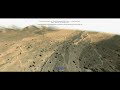 Unity Terrain Streaming System - Intro
 GPX in Unity via GIS Terrain Loader
 GTL Pro Tutorial 01 : Export Data From (GlobalMapper/QGIS) Into Unity
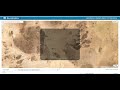 Unity Terrain Streaming System : GIS Data Downloader
 WorldMachine To Unity
 GTL Pro Tutorial 03 : Generate Terrain From Lidar Data
 Terrain Streaming System V2, Tutorial 01 :Download GIS Data
 GIS Terrain Loader Pro Quick Intro
 GIS Data Downloader for Unity