Mars InSight Landing Visualization
This video shows a rendering of the successful landing sequence of the Mars InSight lander on November 26th, 2018. Everything, with the exception of the precise landing location inside the landing ellipse, shown in this video is accurate data, including the features of the Martian surface in the landing area. The movement of the spacecraft is based on a projected descent and the preprogrammed event schedule prior to the landing event, the surface terrain is based on a combination of the Viking Image Mosaic (https://astrogeology.usgs.gov/search/details/Mars/Viking/MDIM21/Mars_Viking_MDIM21_ClrMosaic_global_232m/cub) and the Mars Reconnaissance Orbiter's CTX and HiRISE cameras (https://mars.nasa.gov/mro/mission/instruments/ctx/, https://mars.nasa.gov/mro/mission/instruments/hirise/). All data was used to render this visualization using the open-source software OpenSpace.
The content is rendered using the open-source Astrovisualization framework OpenSpace (http://openspaceproject.com , https://github.com/OpenSpace/OpenSpace) which is a collaboration between Linköping University, the American Museum of Natural History, Goddard's Community Coordinated Modeling Center, New York University, and the University of Utah.
This video is released under the Creative Commons Attribution 4.0 International (CC BY 4.0) license (https://creativecommons.org/licenses/by/4.0/).
Видео Mars InSight Landing Visualization канала OpenSpace
Показать
Комментарии отсутствуют
Информация о видео
Другие видео канала
 7 Minutes of Terror: The Challenges of Getting to Mars
 NASA's Curiosity landing- 1 of her creator's POV
 TianWen-1: China's first independent journey to mars (KSP simulation)
 The Tragic Final Images Of NASA's Opportunity Rover | Opportunity Episode 7
 Getting NASA’s Perseverance Mars Rover to the Launch Pad
 Why Was Mars Insight Launched From California?
 IMAGENS DE MARTE (HD): Imagens da Curiosity Rover / Nasa
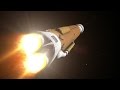 To Bennu and Back
 Mars Science Laboratory - Curiosity Rover - Mission Animation
 Voyage of Curiosity: A Martian Chronicle 4k
 Mars Insight - Digging Into The Martian Interior
 Why NASA’s Mars Mission Can’t Scratch The Surface of Mars
 How China's Chang'e-5 spacecraft will collect, return moon samples
 Opportunity's Last Message: Why did it go silent on Mars?
 This Is What Standing On Mars Sounds Like (Strange!) 4K UHD
 Phoenix Mars Mission: Ashes to Ice
 The Vibrations of NASA's First Ever Marsquake | InSight
 InSight Landed on Mars! What's Next? | SciShow News
 Phoenix Mars Mission: Onto the Ice
 NASA’s InSight Mars landing: what it really took