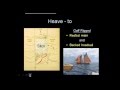
Navigation Preparations for an Advanced Coastal Cruise
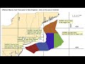
At Maryland School of Sailing & Seamanship we prepare our cruise navigation using paper charts and reference publications to determine our optimum route, course lines, waypoints, hazards and restrictions and to educate the crew on the route to be sailed; then we plot our waypoints on the electronic chart plotter or GPS based on the paper chart plan. During the cruise, we used the paper charts, publications and electronic chart plotter to monitor and manage the cruise navigation.
Видео Navigation Preparations for an Advanced Coastal Cruise канала Maryland School of Sailing
Видео Navigation Preparations for an Advanced Coastal Cruise канала Maryland School of Sailing
Показать
Комментарии отсутствуют
Информация о видео
11 сентября 2020 г. 21:08:07
00:35:37
Другие видео канала
 Storm Tactics & Sea Anchor 2
 "Philosophy of Sailing": Solo to Hawaii and Return, 2017
 How to Read a Nautical Chart Parts 1 & 2
 ATONS Aids to Navigation incl lateral, cardinal, lighthouse, COLREGS and IALA region A and region B
 Captain License Chart Navigation – General Charting What You Need
 A Perfect Cleat Hitch
 Weather Images and Text via SSB Radio
 3 Ways To Sail Faster! Mainsail Trim Techniques
 Protractor Triangle for Paper Chart Plotting
 Navigation - Chart Navigation (Chart Plotting Part 1)
 Gybe Control
 Ep 37: Navigation: Basic Plotting Part 1
 How to Navigate the ICW: Channel Markers, Bridges and Wake Zones
 Sailing in Rough Seas - 16 Squalls, two Knock-Down's & 60+ Knot Winds in the Bermuda Triangle
 Storm Avoidance at Sea
 Buoys & Beacons
 Weather for Sailors
 B&G | Tom Cunliffe | Sailing navigation from the chart table
 Norfolk to Bermuda Cruise- Video Clips