types projection system of nepal |coordinate system MUTM of nepal @ map their type and map scale
The projection system cylindrical conical plannerand used in nepal is the UTM(Universal transverse mercator).mercator projection is conformal cylindrical projection.In teansverse projection,earth is a manner that point of tangency between Globe and Cylinder is a meridian, in line of longitude called central meridian,or conformal or orthographic projection,the shape/angle is preseved even through the length and breath may https://youtu.be/uUT36mWGFSQ
distort.sourcehttp://bit.ly/2ts91cF
#Please_share
#please_channl_subscribe
Видео types projection system of nepal |coordinate system MUTM of nepal @ map their type and map scale канала Engineering Survey
distort.sourcehttp://bit.ly/2ts91cF
#Please_share
#please_channl_subscribe
Видео types projection system of nepal |coordinate system MUTM of nepal @ map their type and map scale канала Engineering Survey
Показать
Комментарии отсутствуют
Информация о видео
Другие видео канала
 Geographic Coordinate System | GCS | PCS | Latitude | Longitude | Datum in HINDI URDU
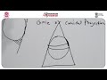 Map projection, coordinate system and datum
 Types of scale given on the map
 Different map projections
 Intro to coordinate systems and UTM projection
 GIS Lecture 4 : What is Geographic Coordinate System || Geoid Ellipsoid Latitude Longitude Altitude
 IT in Nepal | IT Series Episode_01 - Types Of IT(Information Technology) & Who Can Read IT in Nepal?
 Meaning and usage of map scale
 ArcGIS tutorial #1 :Study area map in Nepali
 Classification of Variables and Types of Measurement Scales
 Introduction to UTM, Universal Transverse Mercator
 electromagnetic theory| coordinate system Cartesian,spherical and cylindrical| csir net| iit jam
 UNIVERSAL TRANSVERSE MERCATOR COORDINATE SYSTEM | What is UTM | UNIVERSAL TRANSVERSE MERCATOR
 Introducing Coordinate Systems and Transformations
 Understanding Coordinate Systems and Projections for ArcGIS
 Cylindrical Coordinate System
 Map projections in GIS (theory)
 Latitude and Longitude | Using Coordinates to Find Places on a Map
 GIS Lecture 2 Coordinate system
 Moment of a couple