Hurricane WILMA (High Quality) - Belle Meade, Florida - October 24, 2005
Between October 15th and 26th, 2005 Hurricane WILMA, became the 22nd named storm, 13th hurricane, sixth major hurricane, and fourth category five hurricane of the record-shattering 2005 Atlantic hurricane season. WILMA also has the distinction of producing the lowest central pressure on record in an Atlantic basin tropical cyclone.
From October 15th to 17th Hurricane WILMA gradually organized from an area of disturbed weather over the western Caribbean Sea. Over a 30 hour period from the afternoon of the 18th through the morning of the 19th, Hurricane WILMA underwent explosive deepening with the central pressure falling 100 mb to a record low value of 882 mb (26.05 in), and maximum sustained winds reaching 160 kt (185 mph) with peak gusts over 175 kt (200 mph). After reaching peak intensity, WILMA began an eyewall replacement cycle and weakened slightly, however the hurricane was still a powerful category four with sustained winds of 130 kt (150 mph) as it moved slowly over Cozumel, Mexico and the extreme northeast tip of the Yucatan Peninsula from the 21st through the 23rd.
By the time Hurricane WILMA emerged from the Mexican mainland, on the afternoon of the 23rd, it had weakened significantly, however, the storm began to restrengthen over the eastern Gulf of Mexico as it accelerated to the northeast, ahead of an approaching trough. WILMA regained category three strength, with maximum sustained winds of 110 kt (125 mph) just before landfall on the southwest coast of Florida, near Cape Romano.
WILMA was a very large storm that produced hurricane conditions across almost all of the southern Florida peninsula. The highest winds reported during the hurricane's landfall in Florida were 105 kt (121 mph) at the Collier County EOC near Naples; 102 kt (117 mph) at the Belle Glade SFWMD station, and 98 kt (113 mph) at Loxahatchee. WILMA's minimum central pressure at landfall was 950 mb (28.05 in).
From the evening of October 23rd through mid-morning on the 24th, storm chaser Michael Laca intercepted Hurricane WILMA near the point of landfall on the southwest coast Florida, at the Lely Resort, between Naples and Marco Island. At my location I encountered sustained winds between 80-85 kt (95-100 mph) with peak gusts near 105 kt (120 mph).
Hurricane WILMA moved rapidly across the Florida peninsula and exited the east coast near Jupiter, Florida with maximum winds reduced to near 95 kt (110 mph). The storm restrengthened and once again became a major hurricane, before finally transitioning into a large extra-tropical cyclone over the northern Atlantic.
Across its several landfalls, Hurricane WILMA was responsible for $29.1 billion (adjusted) in damage and 63 direct fatalities.
Видео Hurricane WILMA (High Quality) - Belle Meade, Florida - October 24, 2005 канала Tropmet | Storm Chasing
Показать
Комментарии отсутствуют
Информация о видео
Другие видео канала
 Dust Devil Shakes Palm Trees
 Rolling Thunder: "True Storm Chasing Stories"- Piedmont, OK Supercell & Hail 2012
 STORMY Winds ! Crazy Palm trees fly through the air
 possible tornado caught outside of Talihina Oklahoma. Filmed by High Altitude Media.
 SURVIVING HURRICANE WILMA, Miami, Florida - 2005
 Hurricane ISAAC - New Orleans, Louisiana - August 28-29, 2012
 Extreme 4K Video of Category 5 Hurricane Michael
 Hurricane IGOR - Grotto Bay, Bermuda - September 18-19, 2010
 Super Typhoon Haiyan: Inside the Belly of the Beast
 Hurricane GILBERT (Wes Skiles Tribute) - September 14, 1988 - Playa del Carmen, Mexico
 Hurricane OPAL (High Quality) - Fort Walton Beach, Florida - October 4, 1995
 Hurricane IRMA - Naples, Florida - September 10, 2017
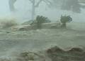 Hurricane Katrina Historic Storm Surge Video - Gulfport, Mississippi
 Trees Falling Compilation #3 No Music
 Labor Day Lightning - Miami, Florida - September 6, 2010
 11 Worst Hurricanes Of All Time
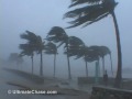 Hurricane Wilma Video - Miami Beach, Florida
 Hurricane BONNIE - High Island, Texas - June 26, 1986
 Hurricane MARIA Devastates Humacao, Puerto Rico (2017)