Land For Sale! Cibola County New Mexico - 43 Acres
Find all the information on this property as well as more listings at www.savvylands.com
Listing webpage: https://www.savvylands.com/cibolanm43ac
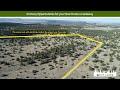
This 43.01 Acres shares a border with 640 Acres of State Land!!!
This is actually four different parcels of land that are connected to each other!
The interior two plots of land are already fenced!
This is a wonderful opportunity to own land in a location where you can rest assured that, because of the 640 acres of state land to the north and the majority of other land owners not living on their parcels, you'll rarely see other people ~ seclusion, peace, serenity!
PROPERTY INFO:
State: New Mexico
County: Cibola
City: Grants
Postal Code: 87020
Size (Acres): 43.01
Property ID #: 10.3 Acres (R04965) ;10.82 Acres (R04944) ; 11 Acres (R04921) ; 10.89 Acres (R04897)
Legal Description: Subd: Tierra Verde Lot: 37A Unit: 2 (Replat) = 10.3 AC
Subd: Tierra Verde Lot: 37B Unit: 2 (Replat) = 10.82 AC
Subd: Tierra Verde Lot: 37C Unit: 2 = 11 AC
Subd: Tierra Verde Lot: 37D Unit: 2 (Replat) = 10.89 AC
Property Address: None - the county can assign one for you if you wish.
Street Name: Camino De Tierra
Cross Street Name: N/A
Zoning: Vacant Land
Power: Powerline approximately 1.1 Miles to the South of Center of Property.
Water: None - you will need to drill a well or use an alternative method.
Sewer: None - you will need to install a septic tank or use an alternative method.
Cable / Internet: In the area.
Roads: Dirt/Gravel
Survey: None - the county can do one for you if you wish. Property lines currently determined by Plat Map.
Property Taxes (Annual): 10.3 Acres (R04965) = $15.60
10.82 Acres (R04944) = $16.38
11 Acres (R04921) = $37.20
10.89 Acres (R04897) = 16.44
Property Back Taxes: None
School District Name: Grants-Cibola County Schools
School District Taxes (Annual): None
School District Back Taxes: None
Association Name: None
Association Fees (Annual): None
Association Back Fees: None
Time Limit to Build: None
General Elevation (Feet): 7,469
General Terrain: Level, Relatively Flat
Flood Zone: No
REFERENCE DOCUMENTS:
VISIT THE PROPERTY WHENEVER YOU WANT - NO APPOINTMENT NECESSARY:
Link to Google Maps: https://goo.gl/maps/H8UYPihLiWSSLrGD6
GPS Coordinates to the Approximate Center of the Property: 34.957314, -108.223842
Northeast Corner of the Property: 34.959327, -108.221556
Southeast Corner of the Property: 34.955520, -108.221556
Southwest Corner of the Property: 34.955529, -108.226202
Northwest Corner of the Property: 34.959494, -108.226212
Driving Directions to the Property:
Note: You should approach this property from the east. Do not approach from the west going through the James Valley subdivision.
Note: Please make sure you are very familiar with the route to the property. Do NOT rely on cell phone service.
1.) Head south on Cibola County Road 42 from Highway 53 aka Ice Caves Rd; travel approximately 7.4 miles down CR 42.
2.) Turn Right (west) on Cerro Americano Rd. You will travel around the south side of an ancient extinct volcano.
3.) Travel approximately 1.5 miles on Cerro Americano Rd.
4.) Stay to the LEFT as you approach a fork in the road, this puts you on to Cerro Leonides Rd.
5.) Travel approximately 2.3 miles on Cerro Leonides (heading westward still)
6.) Turn right (north) on Camino de Agua Vida Rd
7.) Travel approximately 1.94 miles on Camino de Agua Vida due straight north.
8.) Follow the road as it turns left toward the west (this is the Southeast corner of the property).
9.) You are now travelling along the south border of the property (the property is on your right, to the north). You should see the fenced area on your right after .06 miles after turning to the West.
DISTANCES TO THE PROPERTY, FROM:
El Morro : 12.8 Miles to the North
Grants : 49.9 Miles to the Northeast
Albuquerque : 126 Miles to the East
Roswell : 324 Miles to the Southeast
Quemado : 81.4 Miles to the South
Fence Lake : 41.6 Miles to the Southwest
Holbrook AZ : 141 Miles to the West
Gallup : 67.7 Miles to the Northwest
Keywords:
#dreamhome #forsale #fsbo #househunting #instagood #interiordesign #investment #land #landforsale #landscape #panoramic #landscapephotography #love #luxury #luxuryrealestate #nature #photography #photooftheday #property #propertyforsale #propertyinvestment #propertymanagement #realestate #realestatelife #realtorlife #sky #travel #properties #hunting #elk #deer #muledeer #views #mountains #newmexico #nm
Music from Uppbeat (free for Creators!):
https://uppbeat.io/t/hemlock/every-heartbeat
License code: OKTFP0PNL6BRIIFW
Видео Land For Sale! Cibola County New Mexico - 43 Acres канала SavvyLandsUSA
Listing webpage: https://www.savvylands.com/cibolanm43ac
This 43.01 Acres shares a border with 640 Acres of State Land!!!
This is actually four different parcels of land that are connected to each other!
The interior two plots of land are already fenced!
This is a wonderful opportunity to own land in a location where you can rest assured that, because of the 640 acres of state land to the north and the majority of other land owners not living on their parcels, you'll rarely see other people ~ seclusion, peace, serenity!
PROPERTY INFO:
State: New Mexico
County: Cibola
City: Grants
Postal Code: 87020
Size (Acres): 43.01
Property ID #: 10.3 Acres (R04965) ;10.82 Acres (R04944) ; 11 Acres (R04921) ; 10.89 Acres (R04897)
Legal Description: Subd: Tierra Verde Lot: 37A Unit: 2 (Replat) = 10.3 AC
Subd: Tierra Verde Lot: 37B Unit: 2 (Replat) = 10.82 AC
Subd: Tierra Verde Lot: 37C Unit: 2 = 11 AC
Subd: Tierra Verde Lot: 37D Unit: 2 (Replat) = 10.89 AC
Property Address: None - the county can assign one for you if you wish.
Street Name: Camino De Tierra
Cross Street Name: N/A
Zoning: Vacant Land
Power: Powerline approximately 1.1 Miles to the South of Center of Property.
Water: None - you will need to drill a well or use an alternative method.
Sewer: None - you will need to install a septic tank or use an alternative method.
Cable / Internet: In the area.
Roads: Dirt/Gravel
Survey: None - the county can do one for you if you wish. Property lines currently determined by Plat Map.
Property Taxes (Annual): 10.3 Acres (R04965) = $15.60
10.82 Acres (R04944) = $16.38
11 Acres (R04921) = $37.20
10.89 Acres (R04897) = 16.44
Property Back Taxes: None
School District Name: Grants-Cibola County Schools
School District Taxes (Annual): None
School District Back Taxes: None
Association Name: None
Association Fees (Annual): None
Association Back Fees: None
Time Limit to Build: None
General Elevation (Feet): 7,469
General Terrain: Level, Relatively Flat
Flood Zone: No
REFERENCE DOCUMENTS:
VISIT THE PROPERTY WHENEVER YOU WANT - NO APPOINTMENT NECESSARY:
Link to Google Maps: https://goo.gl/maps/H8UYPihLiWSSLrGD6
GPS Coordinates to the Approximate Center of the Property: 34.957314, -108.223842
Northeast Corner of the Property: 34.959327, -108.221556
Southeast Corner of the Property: 34.955520, -108.221556
Southwest Corner of the Property: 34.955529, -108.226202
Northwest Corner of the Property: 34.959494, -108.226212
Driving Directions to the Property:
Note: You should approach this property from the east. Do not approach from the west going through the James Valley subdivision.
Note: Please make sure you are very familiar with the route to the property. Do NOT rely on cell phone service.
1.) Head south on Cibola County Road 42 from Highway 53 aka Ice Caves Rd; travel approximately 7.4 miles down CR 42.
2.) Turn Right (west) on Cerro Americano Rd. You will travel around the south side of an ancient extinct volcano.
3.) Travel approximately 1.5 miles on Cerro Americano Rd.
4.) Stay to the LEFT as you approach a fork in the road, this puts you on to Cerro Leonides Rd.
5.) Travel approximately 2.3 miles on Cerro Leonides (heading westward still)
6.) Turn right (north) on Camino de Agua Vida Rd
7.) Travel approximately 1.94 miles on Camino de Agua Vida due straight north.
8.) Follow the road as it turns left toward the west (this is the Southeast corner of the property).
9.) You are now travelling along the south border of the property (the property is on your right, to the north). You should see the fenced area on your right after .06 miles after turning to the West.
DISTANCES TO THE PROPERTY, FROM:
El Morro : 12.8 Miles to the North
Grants : 49.9 Miles to the Northeast
Albuquerque : 126 Miles to the East
Roswell : 324 Miles to the Southeast
Quemado : 81.4 Miles to the South
Fence Lake : 41.6 Miles to the Southwest
Holbrook AZ : 141 Miles to the West
Gallup : 67.7 Miles to the Northwest
Keywords:
#dreamhome #forsale #fsbo #househunting #instagood #interiordesign #investment #land #landforsale #landscape #panoramic #landscapephotography #love #luxury #luxuryrealestate #nature #photography #photooftheday #property #propertyforsale #propertyinvestment #propertymanagement #realestate #realestatelife #realtorlife #sky #travel #properties #hunting #elk #deer #muledeer #views #mountains #newmexico #nm
Music from Uppbeat (free for Creators!):
https://uppbeat.io/t/hemlock/every-heartbeat
License code: OKTFP0PNL6BRIIFW
Видео Land For Sale! Cibola County New Mexico - 43 Acres канала SavvyLandsUSA
Показать
Комментарии отсутствуют
Информация о видео
Другие видео канала
 Land For Sale! Cibola County New Mexico - 20.6185 Acres
 Brewster County Texas PID 15772 TR 4037
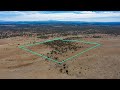 Arizona Hunting Land With A Pond Nearby!
 10 Acres Hudspeth County Texas Remote 4x4 Paradise
 Cochran County Texas 2 25 Acres Hogs Doces Mule Deer
 Catron County, New Mexico PID 2086010162055 10 14 Acres
 Hudspeth County Texas Rio Grande Getaway 10 232 Acres
 Liberty County Texas Water Front Property
 Brewster County TX - Terlingua Ranch Tract 6677 - 10 Acres (+/-)
 10 Acres in Ward County Texas with Electric Lines on the Property!
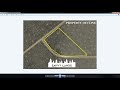 Costilla County Colorado 5 Acres Mountain Views
 25.102 Acres of New Mexico Land With a HUGE HILL!
 40 Acres of Prime Hunting Land in Southwest Arkansas!
 Brewster County, Texas - 5 Acres - Property ID # 20682 & Tract # C174
 20.119 Acres of New Mexico Land With Electricity Along Northern Border
 New Property for Sale Near Cleveland, Texas
 153 Acres in Hudspeth County TX
 Land For Sale! 5 Acres in Duchesne County Utah - Once-In-A-Liftime Type of Property!
 Brewster County, Texas PID 14192 Tract 5155 20 Acres
 New Map Search Function on Savvy Lands Website!