Fagradalsfjall Volcano Iceland - Hike to Meradalir Valley & Viewpoints + footage along the way (4K)
NOTE: This is my last video of the Fagradalsfjall volcano in Iceland for now, as I have just been there on vacation.
The footage here from the hikes is from July 9th and 10th, the eruption footage from July 10th 2021 only.
This is also a video focusing on the hike on trail C (currently offering the best views of and partially into the crater) up north until Meradalir valley, where currently most of the lava flows into.
I wanted to show some hiking footage, the viewpoints along the trail and which perspectives you get from the volcano from each point, so it will hopefully help in case you want to travel there.
The hike we did starts at the unofficial most eastern parking lot, follows the ridge over Langihryggur (296m) down to the saddle, then along the western side of Stóri-Hrútur and up to the top (357m) from the northern side. Return trip is down the south side and then following an unofficial valley trail parallel to Langihryggur - please take a GPS with you if you do this and only go when it is NOT foggy. The trail is not marked and sometimes difficult to find.
Whole hike was about 10.5 km with 500m in elevation gain.
Please take appropriate shoes, especially the trails close to Meradalir can be difficult.
The map screenshots were taken from a very helpful 3D model of the area, which you can find here:
https://sketchfab.com/3d-models/fagradalsfjall-volcanic-eruption-26062021-b53ddf3dd1ce45bfbfaf22c1a062d116
Safety information on the eruption site and the trails can be found here:
https://safetravel.is/eruption-in-reykjanes
A very good offline GPS map of the eruption site and trails can be downloaded here for free (we used this one as well, it was very helpful):
https://www.avenzamaps.com/maps/1266693?
________________________________________________
Hinweis: Dies ist mein letztes Video vom Fagradalsfjall Vulkan in Island für den Moment, da ich lediglich eine Woche dort im Urlaub war.
Die Aufnahmen hier von den Wanderwegen sind vom 9. & 10. Juli, die von der Eruption ausschließlich vom 10.Juli 2021.
Dieses Video fokussiert sich außerdem auf den Wanderweg über Trail C (der aktuell den besten Blick auf bzw. in den Krater bietet) nach Norden bis hin zum Meradalir Tal, wo aktuell ein Großteil der Lava hineinfließt.
Ich wollte hier ein paar Aufnahmen vom Wanderweg zeigen, die einzelnen Aussichtspunkte auf dem Weg und welchen Blick man jeweils auf den Vulkan bekommt, so dass es eventuell hilfreich ist falls man selbst zum Vulkan wandern möchte.
Die Wanderung startete bei uns am inoffiziellen östlichsten Parkplatz, folgt dann dem Bergrücken des Langihryggur (296m) bis zu einem Sattel runter, dann westlich entlang der Flanke des Stóri-Hrútur bis aufwärts auf den Berg (357m) von der nördlichen Seite aus.
Der Rückweg erfolgt abwärts zunächst über die Südflanke in Serpentinen, dann über einen inoffiziellen Weg parallel zum Langihryggur - Bitte hier ein GPS Gerät oder Handy mitnehmen, und nur begehen wenn es nicht neblig ist. Der Weg ist nicht markiert und teils nur schwer zu erkennen.
Die gesamte hier gezeigte Tour hatte 10,5 km und 500 Höhenmeter.
Bitte vernünftiges Schuhwerk tragen, besonders die Wege nahe Meradalir können sehr schwierig sein.
____________________________________
My Equipment / Meine Ausrüstung:
Backpack / Wanderrucksack Salomon* - https://amzn.to/3q6vUN5
Hanwag Hiking Boots / Wanderschuhe* - https://amzn.to/3xvSHnR
Hiking Poles / Wanderstöcke Leki Micro Vario Carbon* - https://amzn.to/3gD8Lif
Cameras / Technical Stuff:
Fuji X-T3
Insta360 One X2* - https://amzn.to/3gBpTEL
Invisible Selfie-Stick* - https://amzn.to/3vNz1e9
GoPro Hero 9 Black* - https://amzn.to/35BXgRQ
Rollei Traveler Tripod / Reisestativ*: https://amzn.to/3idSgJ2
Sony RX100 IV* - https://amzn.to/3gMP8CS
Garmin Fitness Tracke / Fitnessuhr (Fenix 5s)for GPS tracking* - https://amzn.to/3xxnT6d
____________________________
Die mit * gekennzeichneten Links sind Affiliate Links. Als Amazon-Partner verdiene ich an qualifizierten Verkäufen einen kleinen Geldbetrag, die Preise der Produkte ändern sich für dich dadurch nicht.
Ich bin Teilnehmer des Partnerprogramms von Amazon EU, das zur Bereitstellung eines Mediums für Websites konzipiert wurde, mittels dessen durch die Platzierung von Werbeanzeigen und Links zu Amazon.de Werbekostenerstattung verdient werden kann. Zur Nachverfolgung setzt Amazon Cookies ein, die es ermöglichen, zu erkennen, dass Sie einen Partnerlink angeklickt haben. Weitere Informationen zur Datennutzung durch Amazon erhalten Sie in der Datenschutzerklärung des Unternehmens:
https://amzn.to/2DRsTLY
_________________________
Music:
Undertow & Filaments by Scott Buckley – www.scottbuckley.com.au
The music (mp3 downloads) found on scottbuckley.com.au is made available under the Creative Commons ‘Attribution 4.0 International’ (CC BY 4.0) License (unless stated otherwise)
Red Pin PNG Image:
https://de.pngtree.com/so/stift
Видео Fagradalsfjall Volcano Iceland - Hike to Meradalir Valley & Viewpoints + footage along the way (4K) канала Julia Mrozek
Показать
Комментарии отсутствуют
Информация о видео
Другие видео канала
 GSE-5 Tank Work Continues as a New Forward Dome is Sleeved | SpaceX Boca Chica
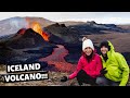 HIKING TO THE ICELAND VOLCANO // Iceland Vlog // Europe Travel 2021
 Iceland Volcano Update - The End Might Be Close & My Channel
 Landscape Photography On Location: Iceland. Snaefellsnes, Mývatn, Jökulsárlón. Midnight Sun.
 Meradalir: Lava pool burst at 14:17 July 17th 2021 - Geldingadalir Volcano, Iceland
 Iceland Volcano – Best Drone Footage
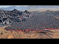 Flowing Pāhoehoe- and ʻAʻā-Lava - Fagradalsfjall, Iceland - May 21, 2021
 Meradalir #2 timelapse July 19th 2021, Geldingadalir Volcano, Iceland
 20 Best Hiking Trails in Iceland (Ring Road) 2021
 Iceland 2021 - A Lonely Golden Circle
 Fagradalsfjall Volcano Iceland (Geldingadalir) - Shots from 10th July - different views & close-ups
 Evolution of Lava Field + Lava Fortifications - Fagradalsfjall Volcanic Eruption in Iceland
 Ahrtal: Drei Türme und ein Aussichtspunkt - Wanderung mit 785hm
 Circling Iceland - Full Iceland Travel Documentary in 4k
 Iceland VOLCANO DAY 123 update JULY 19
 Amazing Sunset Flight Over Iceland's Volcano + How to Get There & Lava Walkabout
 Meradalir timelapse July 17th 2021, Geldingadalir Volcano, Iceland
 Meradalir Valley Flooded, Wide Lava Channel Inadequate/ Iceland Fagradalsfjall Volcano
 Ahrtal: Felsengrat Engelsley - die gesamte Tour von Süd nach Nord bis Burg Are
 RVK Newscast #112: The Volcano Turns Three, And A Farm Is Doomed