The track of Hurricane Harvey
http://www.force-13.com/09L.pdf
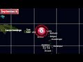
In mid-August, several tropical waves emerged from the coast of Africa, including a wave which emerged from the coast of Senegal and Gambia on August 13th. Initially very broad and disorganised, these waves competed for energy and began acquiring rotation by the 15th. Both waves were being monitored by the National Hurricane Center, and it soon became apparent that the first wave would be the dominant one, and began to resemble the appearance of a tropical cyclone by the 17th, and was named Harvey at the beginning of the next day after a circulation was found.
By this point, the storm was already upon Barbados and crossed through the Lesser Antilles on the morning of August 18th, affecting all islands from Grenada to Martinique. Harvey, whilst never particularly impressive to begin with, began to struggle later on August 19th into the 20th, and degenerated into a tropical wave. The wave became ill-defined as it passed near and over Nicaragua and Honduras, but was closely monitored into August 23rd when it was finally redesignated as a tropical depression.
Early on August 24th, Harvey generated deep convection which sustained itself throughout the day, and before the end of the day an eye began to clear out as it progressed towards the northwest. Hurricane Watches had already been issued for Texas, and by 6pm UTC the storm reached winds of 80mph.
Regular reconnaissance plane coverage saw Harvey’s pressure continually drop, generally at a rate of 1mb per hour, until more rapid intensification began to occur on August 25th in the run-up to landfall. By that afternoon, the eye temperature entered positive temperatures, indicating a significantly strong hurricane,
by which point cold cloud tops had wrapped around most of the eye. This process continued until later in the day, with Harvey peaking as it was making landfall, with winds likely of 140mph and a pressure in the 930s in millibars.
Officially, the National Hurricane Center rated the storm with winds of 130mph and a pressure of 938mb, though their post analysis is likely to upgrade this figure, backed by satellite imagery indications of winds in the 140s.
Harvey made landfall northeast of Corpus Christi, Texas, who as a whole avoided hurricane force winds, but locations to the northeast such as Rockport and Port Aransas saw more severe consequences.
Harvey’s eye remained for eight hours after landfall before disappearing entirely, and rapid weakening took place as the storm continued north, slowing down and then stalling over inland Texas, and delivering unprecedented storm rainfall totals to the region.
On August 28th, Harvey emerged back over the Gulf of Mexico and was still a minimal tropical storm, and some intensification took place as it rounded towards the east and then northeast into its final landfall along the Texas/Louisiana border with winds of 40mph on August 30th. Rainfall continued into the beginning of September as the storm remained identifiable as a depression, before being pushed off towards the northeast and turned post-tropical.
Patreon - https://www.patreon.com/forcethirteen
Merchandise - https://teespring.com/stores/force-thirteen
https://www.Facebook.com/ForceThirteen/
YouTube - https://www.youtube.com/c/Forcethirteen
Twitter - https://twitter.com/ForceThirteen
Discord - https://discord.gg/uFaAAGA
Видео The track of Hurricane Harvey канала Force Thirteen
Показать
Комментарии отсутствуют
Информация о видео
Другие видео канала
 The track of Hurricane Irma
 The track of Hurricane Dorian
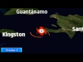 The track of Hurricane Matthew
 Engines of Destruction: The Science of Hurricanes!
 2017 Atlantic Hurricane Season Animation
 2013 Pacific Typhoon Season Animation v.2
 The track of Hurricane Katrina
 Tropical Depression another major Indian Ocean cyclone threat
 2020 Atlantic Hurricane Season Animation
 National Hurricane Center Says Hurricane Laura Has Formed | Morning Joe | MSNBC
 Going Through Hurricane Irma: Before, During, & After
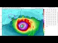 Laura a Strengthening Hurricane Barreling Toward Texas and Louisiana
 Hurricane Laura 10 p.m. Tuesday update | Hurricane Laura intensifies in Gulf
 Tropics Update: Watching Tropical Storm Gonzalo and Tropical Depression 8
 What to expect from Hurricane Laura as it reaches Category 4
 Hurricane Laura expected to strengthen as it approaches Gulf Coast
 Hurricane Laura Archive Footage from Southwest Louisiana
 Hurricane Laura is rapidly intensifying as it heads towards the Gulf Coast l GMA
 2021 Atlantic Hurricane Season Animation
 Hurricane Laura 8:35 a.m. Wednesday update | Laura is now a major Category 3 hurricane