- Популярные видео
- Авто
- Видео-блоги
- ДТП, аварии
- Для маленьких
- Еда, напитки
- Животные
- Закон и право
- Знаменитости
- Игры
- Искусство
- Комедии
- Красота, мода
- Кулинария, рецепты
- Люди
- Мото
- Музыка
- Мультфильмы
- Наука, технологии
- Новости
- Образование
- Политика
- Праздники
- Приколы
- Природа
- Происшествия
- Путешествия
- Развлечения
- Ржач
- Семья
- Сериалы
- Спорт
- Стиль жизни
- ТВ передачи
- Танцы
- Технологии
- Товары
- Ужасы
- Фильмы
- Шоу-бизнес
- Юмор
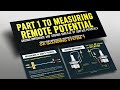
3D Close Interval Survey + KMZ Google Earth
✅ Multi-technique data ingestion: Processes CIS (Close Interval Survey), DCVG, ACVG, PCM, SCM, and ILI files from multiple instrument manufacturers (Allegro, Pipeline Solutions, and others).
✅ ON / OFF potential analysis in accordance with NACE SP0169 / AMPP SP0169 and ISO 15589-1, applying the −850 mV CSE minimum protection criterion, with automatic detection of unprotected zones, overprotected zones (below −1200 mV), and reversed potential anomalies.
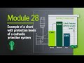
✅ Interactive 3D visualization of potential profiles along the pipeline route, with separate rendering of ON potential (blue) and OFF potential (dynamic heat map by protection severity), with elevations proportional to the measured potential value.
✅ Automatic KMZ generation with organized layers for Google Earth:
Georeferenced pipeline route
ON / OFF measurement points color-coded by protection status
NACE criterion lines at −850 mV and −1200 mV at fixed 3D altitudes
Icons for current entry, current discharge, and reversed potential (stray current interference)
Semi-transparent rectangles highlighting zones with multiple anomalies
Bilingual ES / EN popups with full technical diagnosis and normative references (NACE SP0169 §6.3, EN 50162)
✅ Risk & Integrity Module based on API 581 / ASME B31.8S:
Multi-threat Probability of Failure (POF)
Consequence of Failure (COF): people, environment, finances
5×5 risk matrices with heatmap rendering
Pipeline segment ranking by criticality index
Automated inspection planning with suggested intervals and techniques
✅ Advanced corrosion calculations:
Corrosion rate (CR in mm/year) via Faraday's Law (equivalent factor = 1.459 mm/year per µA/cm²)
Corrosion current density (i_corr in µA/cm²)
Estimated remaining service life
Soil aggressivity classification by resistivity (NACE SP0169 Appendix D)
✅ Multi-technique correlation engine: Automatic spatial alignment of CIS + DCVG + PCM + ILI data by pipeline stationing (PK) using snap/interpolation algorithms.
✅ Professional deliverable export:
KMZ / KML for Google Earth (bilingual ES / EN)
Multi-sheet Excel workbook (corrosion, POF, COF, risk, inspection plan)
Professional PDF reports with embedded Matplotlib charts
📐 STANDARDS APPLIED:
NACE SP0169 · NACE SP0207 · NACE SP0502 · ISO 15589-1 · EN 13509 · EN 50162 · ASME B31.8S · API 581
Видео 3D Close Interval Survey + KMZ Google Earth канала MrCathodic -Corrosion Pedro Argenis Morales Moreno
✅ ON / OFF potential analysis in accordance with NACE SP0169 / AMPP SP0169 and ISO 15589-1, applying the −850 mV CSE minimum protection criterion, with automatic detection of unprotected zones, overprotected zones (below −1200 mV), and reversed potential anomalies.
✅ Interactive 3D visualization of potential profiles along the pipeline route, with separate rendering of ON potential (blue) and OFF potential (dynamic heat map by protection severity), with elevations proportional to the measured potential value.
✅ Automatic KMZ generation with organized layers for Google Earth:
Georeferenced pipeline route
ON / OFF measurement points color-coded by protection status
NACE criterion lines at −850 mV and −1200 mV at fixed 3D altitudes
Icons for current entry, current discharge, and reversed potential (stray current interference)
Semi-transparent rectangles highlighting zones with multiple anomalies
Bilingual ES / EN popups with full technical diagnosis and normative references (NACE SP0169 §6.3, EN 50162)
✅ Risk & Integrity Module based on API 581 / ASME B31.8S:
Multi-threat Probability of Failure (POF)
Consequence of Failure (COF): people, environment, finances
5×5 risk matrices with heatmap rendering
Pipeline segment ranking by criticality index
Automated inspection planning with suggested intervals and techniques
✅ Advanced corrosion calculations:
Corrosion rate (CR in mm/year) via Faraday's Law (equivalent factor = 1.459 mm/year per µA/cm²)
Corrosion current density (i_corr in µA/cm²)
Estimated remaining service life
Soil aggressivity classification by resistivity (NACE SP0169 Appendix D)
✅ Multi-technique correlation engine: Automatic spatial alignment of CIS + DCVG + PCM + ILI data by pipeline stationing (PK) using snap/interpolation algorithms.
✅ Professional deliverable export:
KMZ / KML for Google Earth (bilingual ES / EN)
Multi-sheet Excel workbook (corrosion, POF, COF, risk, inspection plan)
Professional PDF reports with embedded Matplotlib charts
📐 STANDARDS APPLIED:
NACE SP0169 · NACE SP0207 · NACE SP0502 · ISO 15589-1 · EN 13509 · EN 50162 · ASME B31.8S · API 581
Видео 3D Close Interval Survey + KMZ Google Earth канала MrCathodic -Corrosion Pedro Argenis Morales Moreno
Cathodic Protection Corrosion Control Integrity Management Industrial Coating ICCP Oil and Gas Industry Pipelines Chemical Engineering NACE AMPP Pipeline Integrity Galvanic Corrosion Failure Analysis Corrosion Mitigation Protective Coatings #StrayCurrents #3D #KMZ #CloseIntervalSurvey #CIS #ILI #CorrosionEngineering #AMPP #Dash #GoogleEarth #NACE #CathodicProtection #PipelineIntegrity #DCVG #PCM #ASMEB318S #PipelineEngineering #API581
Комментарии отсутствуют
Информация о видео
7 апреля 2026 г. 18:42:16
00:24:44
Другие видео канала