Driving 4K: Canary Wharf & Isle of Dogs, London, UK
Date of filming: 13 February 2021
Location: Canary Wharf & Isle of Dogs, London, UK
Equipment: DJI Osmo Pocket at 4k 60fps
Edited with DaVinci Resolve
No sound
My first attempt at a driving video around Canary Wharf & the Isle of Dogs in East London (UK) where I have lived for over 20 years now. The local area has developed so much so I thought it would be nice to drive around and show people how it looks in 2021. Hope you like the video and please remember to like, share & subscribe!
Canary Wharf is the secondary central business district of London on the Isle of Dogs. Along with the City of London, it is one of the main financial centres in the United Kingdom and the world, containing many high-rise buildings including the third-tallest in the UK, One Canada Square.
Canary Wharf is 97 acres (39 hectares) and contains around 16,000,000 square feet (1,500,000 m2) of office and retail space. It comprises many open areas, including Canada Square, Cabot Square and Westferry Circus. Together with Heron Quays and Wood Wharf, it forms the Canary Wharf Estate.
https://en.wikipedia.org/wiki/Canary_Wharf
The Isle of Dogs is a large peninsula bounded on three sides by a large meander in the River Thames in East London, England, which includes the Cubitt Town, Millwall and Canary Wharf districts. The area was historically part of the Manor, Hamlet, Parish and, for a time, the wider borough of Poplar. The name had no official status until the 1987 creation of the Isle of Dogs Neighbourhood by Tower Hamlets London Borough Council. It has been known locally as simply "the Island" since the 19th century.
The whole area was once known as Stepney Marsh; Anton van den Wyngaerde's "Panorama of London" dated 1543 depicts and refers to the Isle of Dogs. Records show that ships preparing to carry the English royal household to Calais in 1520 docked at the southern bank of the island. The name Isle of Dogges occurs in the Thamesis Descriptio of 1588, applied to a small island in the south-western part of the peninsula. The name is next applied to the Isle of Dogs Farm (originally known as Pomfret Manor) shown on a map of 1683. At the same time, the area was variously known as Isle of Dogs or the Blackwell levels. By 1855, it was incorporated within the parish of Poplar under the aegis of the Poplar Board of Works. This was incorporated into the Metropolitan Borough of Poplar on its formation in 1900.
https://en.wikipedia.org/wiki/Isle_of_Dogs
Видео Driving 4K: Canary Wharf & Isle of Dogs, London, UK канала Travel To
Показать
Комментарии отсутствуют
Информация о видео
Другие видео канала
 Walking in Canary Wharf 4k Exploring London UK 🇬🇧
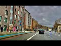 London drive | East London, City of London | during full national lockdown 2021
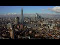 London Drone Flight
 Walk around Istanbul 4K. Kadıköy Pier Moda Bağdat Caddesi Bostancı.
![Cycling in London: Canary Wharf, Isle of Dogs (to Traffic Light Tree) [4K]](https://i.ytimg.com/vi/dZZQBNMutrw/default.jpg) Cycling in London: Canary Wharf, Isle of Dogs (to Traffic Light Tree) [4K]
Cycling in London: Canary Wharf, Isle of Dogs (to Traffic Light Tree) [4K] 4K London Night Walk - Canary Wharf WINTER LIGHTS 2020
 London Districts: Canary Wharf (Documentary)
 Miami 4K - Vice City - Driving Downtown
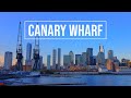 Canary Wharf, London 🇬🇧
 London 4K - Canary Wharf - Driving Downtown - England
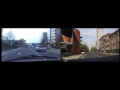 Isle of Dogs Road Trip 1989 & 2014 (with commentary)
 Driving into Central London from the North
 Relaxing Downtown Drive Oslo, Norway (Relaxing Binaural Traffic Sounds for Sleep) 4k ASMR
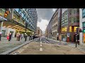 Financial City Of London Looks Empty-During Tier4 Lockdown of 2021, 4k Walk
 Canada Square Is A Billion Dollar Gamble That Almost Went Horribly Wrong | Vertical City | Spark
 A Trip Around the Old Isle of Dogs
 London Districts: Millwall (Documentary)
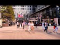 Canary Wharf And Jubilee Park City Tour 2020 | The Financial District of London | LONDON WALK
 London 4K - Skyscraper District Drive - City of London
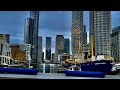 Skyscrapers City of London | Canary Wharf | Walk around Dollars bay Marina during Lockdown 2021,