- Популярные видео
- Авто
- Видео-блоги
- ДТП, аварии
- Для маленьких
- Еда, напитки
- Животные
- Закон и право
- Знаменитости
- Игры
- Искусство
- Комедии
- Красота, мода
- Кулинария, рецепты
- Люди
- Мото
- Музыка
- Мультфильмы
- Наука, технологии
- Новости
- Образование
- Политика
- Праздники
- Приколы
- Природа
- Происшествия
- Путешествия
- Развлечения
- Ржач
- Семья
- Сериалы
- Спорт
- Стиль жизни
- ТВ передачи
- Танцы
- Технологии
- Товары
- Ужасы
- Фильмы
- Шоу-бизнес
- Юмор
Combler les lacunes avec ENVI/Gapfill in Landsat 7 ETM+ using ENVI
le lien https://docs.google.com/file/d/0B3e_wo8OTO47b3c4ZHNyV0NmUkk/edit?pli=1
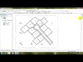
Image Gap Filling
Use the ENVI software program to open the two Landsat ETM images you have selected above. If you are using ENVI Standard interface look under Toolbox | Extensions | landsat_gapfill. If using ENVI Classic, from the main menu bar, select Basic Tools | Preprocessing | Data-Specific Utilities | Landsat TM | Landsat Gapfill. This will open the Select input file(s) and processing type dialog. You should only use the option Two band gap-fill (Local histogram matching), the other options do not perform as well. Next, click on the Choose button to navigate to a folder and enter an output filename.
Click OK to open the Select input files dialog box. Make sure you select the appropriate image data type; 30m multispectral, 60m thermal, or 15m pan. Select your master image as the image to be gap filled then select the second image; you will use this to fill gaps in the first image. Click OK and wait for this to complete.
Видео Combler les lacunes avec ENVI/Gapfill in Landsat 7 ETM+ using ENVI канала ZHOUR ENNOUALI
Комментарии отсутствуют
Информация о видео
15 апреля 2022 г. 21:00:33
00:04:54
Другие видео канала