Applying a Geospatial Strategy at Airports Webinar
The advances in GIS have allowed airports to think spatially in new ways. This webinar will identify the more common options airports have chosen as well as some emerging ones including 3D capabilities, geospatial cloud services, and interior wayfinding to create a smooth customer journey. Approaches to implementing GIS, as well as maintenance and support requirements will be covered. Integrating GIS with other airport information systems such as lease, asset, and financial management systems will also be shown.
---------------------------------------------------------------------------------------------------
Follow us on Social Media!
Twitter: https://twitter.com/Esri
Facebook: https://facebook.com/EsriGIS
LinkedIn: https://www.linkedin.com/company/esri
Instagram: https://www.instagram.com/esrigram
The Science of Where: http://www.esri.com
Видео Applying a Geospatial Strategy at Airports Webinar канала Esri Industries
Показать
Комментарии отсутствуют
Информация о видео
Другие видео канала
 Plan and Manage Special Events with the Latest GIS Tools
 AEC Community Webinar Series—July: Automated Aerial Reality Capture
 Informing COVID-19 Response with Location Intelligence Webinar
 Esri & AgileAssets: Best Practices for Pavement Management
 Best Field Practices for Collecting Geospatial Data
 Introduction to Geospatial Science & Technology (GIS&T): Complete lecture.
 Webinar -Taking your UAS Missions to a higher level using real time geospatial analysis
 Webinar: 3D Planning with SketchUp and CityEngine
 Impulsa la Modernización Digital de la Red Ahora
 Esri Fire and EMS Webinar Series: Data Analysis for the Fire Service
 Mastering ArcGIS Expressions with Python, Arcade, and SQL
 Data for Design: Enhance Workflows through Data Integration
 Creating Smarter Utilities – How Esri and Schneider Electric are Bringing GIS into the Future
 #MySQL and #Geospatial Programming - MySQL Tutorial - Michael Benshoof
 Impacting the Future - How 3D GIS Informs Smart Planning
 Distributed Collaboration: Sharing Data Across Systems
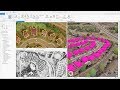 Creating 3D GIS from Imagery and Lidar
 Using PostGIS to Handle Geospatial Data - Dylan Herron
 7 Steps to Getting Started with the ArcGIS Utility Network
 Business Analyst for Commercial Real Estate