New maps show how a tsunami could impact Seattle and inland Puget Sound
Could a tsunami, which starts miles off Washington’s coast, make its way deep into Puget Sound or Hood Canal? New maps from the Washington Geological Survey show it's likely.
Parts of low-lying Bellingham could find themselves under nearly 11 feet of water. Part of the Snohomish River Delta between Everett and Marysville could get nearly six feet and Seattle’s Harbor Island could be inundated with nearly four feet of water.
The maps show slightly lower effects in the south Sound, with the Port of Tacoma getting three-and-a-half feet and low-lying areas of Olympia could receive six inches.
The area that could see the worst inundation is Belfair, at the tip of Hood Canal, which could see depths of 14 feet. https://www.king5.com/article/weather/earthquakes/new-maps-show-how-a-tsunami-could-impact-seattle-and-puget-sound/281-199e4224-07fa-4d31-9464-71976b1e8a01
Видео New maps show how a tsunami could impact Seattle and inland Puget Sound канала KING 5
Показать
Комментарии отсутствуют
Информация о видео
Другие видео канала
 Seattle Streets Walking Tour - 4K City Walk Video - Short Preview
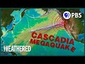 Will the Cascadia Earthquake be the Worst Disaster North America’s Ever Seen? | Weathered
 Norway's Cruise Ship Tunnel Plan Explained
 Growing lemons on the Amalfi Coast
 Explained | World's Water Crisis | FULL EPISODE | Netflix
 VIDEO: Man who bought ?residential? firehouse sued by Seattle - for using as residence
 Glacier Calving | 15 Amazing Collapses, Tsunami Waves and Icebergs
 Where Does the Poop in Antarctica Go? | Antarctic Extremes
 Announcement | Marvel Studios' Loki | Disney+
 Scientists Dug the Deepest Hole But Something Broke Their Drill
 As eviction ban expirations loom, City Inside/Out looks at rent relief
 Uncut and Unseen: Greenland Tsunami (First Wave to Largest Wave in 6 mins.)
 "If You Have Ideas, We Want To Hear Them" - Sen. Sanders To GOP On Climate Change
 Ryan Sheckler: Wasting $1M on bottle service, penthouse suites
 My Solo Weekend Trip to Seattle! | Things to do in Seattle
 Long Beach, Washington 2021 (Pacific Ave, Boardwalk) Virtual Walk 4k
 KING 5 weather
 Chinese Rocket OUT-OF-CONTROL Hurtles Towards Earth
 Trump's 'Scared!': Michael Cohen Says Rudy 'Knows He's In Trouble' And Will Flip On Trump
 Foggy Evening Walk at Ruby Beach, Washington (Binaural Ocean Sounds)