Trimble X7 Scanning System - Overview
https://geospatialx7.trimble.com to learn more.
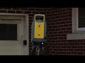
The Trimble X7 is an easy-to-use survey grade 3D scanning system. It will change the way you scan with intuitive field software, a self-leveling system, auto-calibration, and auto-registration capabilities.
The Trimble X7 is a great system for a surveyor or engineer that has never purchased a scanner before. It’s easy to learn, set-up, use and track your scanning progress in the field. This system is also ideal for experienced scanning professionals will benefit from the self-leveling, auto-calibration, and registration assist features that will make them more productive in the field, and deliver results to clients faster.
Видео Trimble X7 Scanning System - Overview канала Trimble Geospatial
Показать
Комментарии отсутствуют
Информация о видео
Другие видео канала
 Trimble X7 Scanner
 Trimble X7 with Trimble Field Link.
 3D Scan to CAD with Trimble X7 Laser Scanner and Geomagic Wrap
 Trimble SX10 Workflow
 What is Scan to BIM?
 Introducing Trimble X7 Scanning System
 8 INVENTIONS AND TECHNOLOGIES THAT WILL CHANGE OUR WORLD!
 InFocus - Next Generation Scanning, The Trimble TX Series
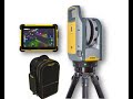 Scanning workflows with the Trimble X7 laser scanner
 How to Geo-reference Your X7 Scan Data | Trimble Forensics
 Rounds in Trimble Access Explained
 WEBINAR | Trimble X7 for Geospatial Professionals
 Laser Scanning for As-Built Drawings
 Head to head: Trimble R8s vs. Trimble R12
 LASER SCANNER - DAL RILIEVO ALL'ELABORAZIONE DATI
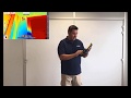 Trimble X7 workflow
 R12i Tutorial: Complete Video Series
 RTC360 demo field
 Trimble + ARCHICAD: dalla nuvola di punti alla restituzione del modello BIM
 GPS Search for surveying with a Trimble Robotic Total Station