Satellite images show scale of Beirut blast
Comparing satellite images of Beirut’s blast area from May 31 and August 5 shows the scale of the massive explosion that destroyed part of the city’s port area. Visit tgam.ca/33tTSIL for more.
Follow The Globe and Mail:
Instagram: instagram.com/globeandmail
Twitter: twitter.com/globeandmail
Facebook: facebook.com/theglobeandmail
Видео Satellite images show scale of Beirut blast канала The Globe and Mail
Follow The Globe and Mail:
Instagram: instagram.com/globeandmail
Twitter: twitter.com/globeandmail
Facebook: facebook.com/theglobeandmail
Видео Satellite images show scale of Beirut blast канала The Globe and Mail
Показать
Комментарии отсутствуют
Информация о видео
Другие видео канала
 Aftermath of explosion at Beirut port
 Beirut, l'esplosione devasta il reparto: il video dell'infermiera che salva i neonati prematuri
 Beirut Blast: The explosion that stole a nation's hope | Four Corners
 CCTV captures moment tanker truck explodes in Italy
 Footage shows the moment the devastating quake shatters Nepal | Mashable
 New footage of Boston bombing blast shown in court
 Lebanon: Dramatic footage shows wedding interrupted by Beirut blasts *EXCLUSIVE*
 What caused Beirut's devastating explosion?
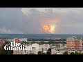 Explosions rock Russian ammunition depot in Siberia
 Beirut explosion: Moment of deadly blast captured in second wedding photoshoot
 Beirut explosion rocks bride's photoshoot
 Beirut Blast Blows Out Windows Behind Wedding Couple
 Tsunami visualization
 Inside Beirut After the Explosion | WSJ
 How the Beirut explosion was a government failure
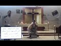 Beirut explosion: priest dodges falling debris as shockwave hits church during mass
 “Am I going to die?” Couple recalls the moment of Beirut blast
 Hiroshima: Dropping The Bomb - Hiroshima - BBC
 Explosion de Beyrouth : le désastre reconstitué
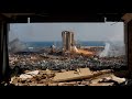 Investigators discover underground panic rooms at site of Beirut explosions