Understanding the Operational Environment Demo
The Intelligence Preparation of the Battlespace is a key function in the military decision-making process that analyzes the enemy, terrain, weather, and civil considerations for an understanding of the operational environment and the planning of a relevant course of action (COA) to support the warfighter. Even though parts of the environment can be static, the majority of conditions are dynamic, therefore we need to integrate the data at speed to collaborate on joint information products that provide intelligence at near real time.
For more information, please visit: http://ow.ly/qn4W50CB3hW
---------------------------------------------------------------------------------------------------
Follow us on Social Media!
Twitter: https://twitter.com/Esri
Facebook: https://facebook.com/EsriGIS
LinkedIn: https://www.linkedin.com/company/esri
Instagram: https://www.instagram.com/esrigram
The Science of Where: http://www.esri.com
Видео Understanding the Operational Environment Demo канала Esri Industries
Показать
Комментарии отсутствуют
Информация о видео
Другие видео канала
 An Introduction to Infographics in ArcGIS
 Esri Pipeline Webinar Series — Modernizing Pipeline GIS
 Agronomic Analysis with ArcGIS and Ag-Analytics
 AT&T Archives: The UNIX Operating System
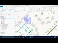 Getting to Know the Utility Network
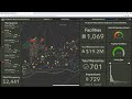 Enabling Installation Facility Managers with Focused Web Apps
 Equitable Property Value Update
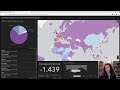 Automation HNS Demo
 Esri Mining Webinar Series – Implementing Geoscience Workflows in ArcGIS Pro Part II
 Access MRW Demo
 Advancement SCP Demo
 Geographic Information Systems (GIS): Dan Scollon at TEDxRedding
 Spatial Thinking for Leaders
 Smart Planning | Designing Thriving Communities with GIS
 Creating the future with GIS
 Using GIS to Support Equitable and Speedy Vaccine Distribution (Hosted by NSGIC)
 South China Sea Demo
 Applying The Science of Where
 Navajo Nation: Modeling and Surge Capacity
 Navajo Nation: Future of GIS