- Популярные видео
- Авто
- Видео-блоги
- ДТП, аварии
- Для маленьких
- Еда, напитки
- Животные
- Закон и право
- Знаменитости
- Игры
- Искусство
- Комедии
- Красота, мода
- Кулинария, рецепты
- Люди
- Мото
- Музыка
- Мультфильмы
- Наука, технологии
- Новости
- Образование
- Политика
- Праздники
- Приколы
- Природа
- Происшествия
- Путешествия
- Развлечения
- Ржач
- Семья
- Сериалы
- Спорт
- Стиль жизни
- ТВ передачи
- Танцы
- Технологии
- Товары
- Ужасы
- Фильмы
- Шоу-бизнес
- Юмор
AWN Thursday 5/7/26 Morning Statewide Forecast Update from James Spann
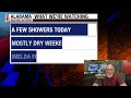
South Alabama starts the day with a vivid show of lightning and very efficient heavy-rain storms, while the rest of the state trends quieter as the morning goes on.
Severe weather isn’t the main story for most communities today, but the far southeast corner still has a Level 2/5 risk this morning for gusty winds and an isolated brief tornado. The bigger concern is flooding where storms train over the same areas, especially across the southern counties.
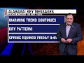
After storms exit around midday, the pattern turns mostly dry for much of the state this afternoon and again for most of Friday. A wave along the front brings another increase in showers late Friday into Friday night, and the weekend keeps periodic rain chances around — with the better coverage likely over south Alabama.
Rainfall adds up over the next several days, with higher totals possible in south Alabama and lighter amounts north.
Chapters:
0:00 Introduction
0:18 SkyCam Tour
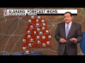
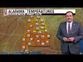
3:24 Forecast Highs
4:22 Future Cast
4:58 South Alabama Forecast
5:10 North Alabama Forecast
alabamaweathernetwork.com
Видео AWN Thursday 5/7/26 Morning Statewide Forecast Update from James Spann канала Alabama Weather Network
Severe weather isn’t the main story for most communities today, but the far southeast corner still has a Level 2/5 risk this morning for gusty winds and an isolated brief tornado. The bigger concern is flooding where storms train over the same areas, especially across the southern counties.
After storms exit around midday, the pattern turns mostly dry for much of the state this afternoon and again for most of Friday. A wave along the front brings another increase in showers late Friday into Friday night, and the weekend keeps periodic rain chances around — with the better coverage likely over south Alabama.
Rainfall adds up over the next several days, with higher totals possible in south Alabama and lighter amounts north.
Chapters:
0:00 Introduction
0:18 SkyCam Tour
3:24 Forecast Highs
4:22 Future Cast
4:58 South Alabama Forecast
5:10 North Alabama Forecast
alabamaweathernetwork.com
Видео AWN Thursday 5/7/26 Morning Statewide Forecast Update from James Spann канала Alabama Weather Network
Комментарии отсутствуют
Информация о видео
7 мая 2026 г. 17:14:45
00:06:13
Другие видео канала