RTC360: What is VIS?
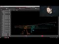
If you’ve ever had to register point clouds from laser scanning, you know how time-consuming the process can be. The Leica RTC360 eliminates this process with a technology called VIS (visual inertial system). With VIS, five cameras give the IMU “eyes” to produce an accurate station-to-station position. This, in turn, enables easy in-field registration during data collection, enabling you to create high-value deliverables from your scan data much faster. Watch the video to see VIS in action with Cyclone FIELD 360.
To learn more, visit www.StepIntoTheFuture.today
Видео RTC360: What is VIS? канала Leica Geosystems US & Canada
To learn more, visit www.StepIntoTheFuture.today
Видео RTC360: What is VIS? канала Leica Geosystems US & Canada
Показать
Комментарии отсутствуют
Информация о видео
8 августа 2018 г. 20:22:51
00:05:53
Другие видео канала
 Register360 Advanced Tips and Tricks
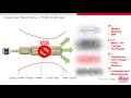 RTC360: Boosting ROI with VIS
 Exploring the Cyclone FIELD 360 app: Reality Capture in the Palm of your Hands
 Z+F IMAGER® 5016 - Reaching new levels
 Leica RTC360 - The first setup and moving the scanner using VIS
 11. Setting Target Ranges with BLK360
 Leica Absolute Tracker ATS600: A new concept in large-volume metrology
 【実検証】スマホ撮影した点群データは現場測量に使えるのか⁉︎ 戸建外構を現調(測量)して精度を調べてみた #42
 Z+F IMAGER® 5016 and Z+F LaserControl®
 Workflow Demonstration: Leica RTC360 3D Laser Scanner
 Leica Cyclone FIELD 360 Quick Plan
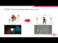 How the RTC360 Eliminates Registration with VIS
 Leica Geosystems RTC360 Data in Cyclone REGISTER 360
 Особенности лазерного сканера Leica RTC360
 Leica RTC360 3D Reality Capture Solution
 How to set up HERON LITE Color
 Leica RTC360 Construction Laser New Office Virtual Tour
 Basics of Reg360 PT 5 UCS
 3D Laser Scanner Leica RTC360 Portcoast BIM
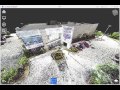 Laser Scanning for As-Built Drawings