- Популярные видео
- Авто
- Видео-блоги
- ДТП, аварии
- Для маленьких
- Еда, напитки
- Животные
- Закон и право
- Знаменитости
- Игры
- Искусство
- Комедии
- Красота, мода
- Кулинария, рецепты
- Люди
- Мото
- Музыка
- Мультфильмы
- Наука, технологии
- Новости
- Образование
- Политика
- Праздники
- Приколы
- Природа
- Происшествия
- Путешествия
- Развлечения
- Ржач
- Семья
- Сериалы
- Спорт
- Стиль жизни
- ТВ передачи
- Танцы
- Технологии
- Товары
- Ужасы
- Фильмы
- Шоу-бизнес
- Юмор
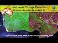
Downloading ESRI 2020 Global Land Cover Data
In this tutorial, we will discuss about the new Global Land Cover Dataset which was released collaboratively by ESRI and Impact Observatory institute. If we look at the background of this dataset, it is making use of the multispectral images produced by Sentinel 2 satellite (2020) to derive this land cover data via a deep learning artificial intelligence classification model. This land cover product has a spatial resolution of 10m x 10m, and the land cover types are categorized into 10 different classes; Water, Trees, Grass, Flooded Vegetation, Crops, Scrub/ Shrub, Built Areas, Bare Ground, Snow/ Ice and Clouds.
Web-link: https://livingatlas.arcgis.com/landcover/
#esri #landcover #sentinel2
Видео Downloading ESRI 2020 Global Land Cover Data канала GeoDelta Labs
Web-link: https://livingatlas.arcgis.com/landcover/
#esri #landcover #sentinel2
Видео Downloading ESRI 2020 Global Land Cover Data канала GeoDelta Labs
land cover and land use in remote sensing land cover mapping land cover change land cover mapping by arcgis land cover classification of landsat images land cover gis land cover classification land cover classification using sentinel-2 data land cover change analysis ESRi land cover map download ESRI global land cover map download land use data download ESRI land cover data ESRI land cover data 2020 Global Land Use Data land cover data download land cover data
Комментарии отсутствуют
Информация о видео
5 июля 2021 г. 18:11:39
00:10:51
Другие видео канала