How will the snow impact Colorado’s wildfires?
COLORADO, USA — The National Weather Service (NWS) website has a map that's a patchwork of warnings across Colorado, with large wildfires in the midst of winter weather advisories and some air quality and high wind concerns thrown in for good measure.
The overall message? Colorado is in for a wild ride Monday night into Tuesday and Wednesday, as near-record temperatures give way to highs in the 30s and snow for much of the Front Range.
It's a forecast that has everyone taking screenshots of their weather apps ... and asking some pretty legitimate questions. Below are the answers to the some of the most common:
When is the cold front going to blow in?
The cold front is coming from the north, meaning that northern Colorado will get hit with what could be 45 mph wind gusts first, likely late Monday night.
The storm will move south, bringing high winds to the Denver metro area and Front Range early Tuesday morning.
Ninety-degree temperatures in Denver will plunge into the 40s early Tuesday morning, and then into the mid-30s as the front continues to blow in.
Tuesday's coldest temperatures will be at around 8 a.m., and that's also when snow will begin to fall.
When will it start snowing?
As of right now, it will begin to snow on the Front Range early Tuesday morning, and continue throughout the day into Wednesday morning.
It will start with rain, but turn into snow as temperatures get colder.
Wednesday will be even colder, with temperatures dipping into the low 30s -- meaning that yes, now's the time to protect your plants and sprinklers from a potential freeze.
Видео How will the snow impact Colorado’s wildfires? канала KSDK News
Показать
Комментарии отсутствуют
Информация о видео
Другие видео канала
 Fire and snow: What to expect from Colorado's wild weather shift Monday into Wednesday
 Everything You Need To Know About Driving In The Snow
 Animated Maps: California Wildfires from 1910-2019
 What's really hiding under Cheyenne Mountain in Colorado?
 The Science Behind Ice Thickness
 Terrifying proof of global warming | 60 Minutes Australia
 Denver7 News 6 AM | Tuesday, September 8
 Regional wildfires close roads, back up traffic across Eastern Washington
 Strong winds, light snow on I-70 in the mountains
 Top 10 Must-See Destinations on a Western Road Trip
 Colorado Farm Welcomes Guests To Pick Produce Before Storm
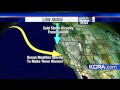 Snow In Sacramento?
 Colorado's Underground Fire
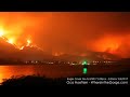 Timelapse Video: Wildfire Spreads Near Portland
 09-07-20 Keystone, SD - Mount Rushmore Early Snowfall
 03-15-2018 Cheyenne Wy. Heavy Snow, Accidents, Plows
 How much snow will fall? Hourly Colorado forecast from Denver7 Weather
 The Best Towns in Colorado
 Fire and snow: What to expect from Colorado's wild weather shift Monday into Wednesday
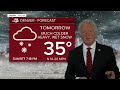 Colorado Winter weather timeline: How much snow will fall where?