- Популярные видео
- Авто
- Видео-блоги
- ДТП, аварии
- Для маленьких
- Еда, напитки
- Животные
- Закон и право
- Знаменитости
- Игры
- Искусство
- Комедии
- Красота, мода
- Кулинария, рецепты
- Люди
- Мото
- Музыка
- Мультфильмы
- Наука, технологии
- Новости
- Образование
- Политика
- Праздники
- Приколы
- Природа
- Происшествия
- Путешествия
- Развлечения
- Ржач
- Семья
- Сериалы
- Спорт
- Стиль жизни
- ТВ передачи
- Танцы
- Технологии
- Товары
- Ужасы
- Фильмы
- Шоу-бизнес
- Юмор
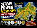
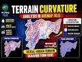
Morphometric Analysis in ArcGIS Part 1 | DEM Preprocessing & Watershed Delineation Step by Step
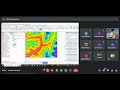
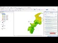
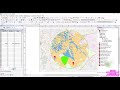
In this tutorial, we start Morphometric Analysis in ArcGIS Part 1, where we focus on DEM pre-processing and watershed delineation using hydrology tools in ArcMap. This step-by-step guide explains how to prepare DEM data and extract the drainage basin required for GIS morphometric analysis.
Morphometric analysis is widely used in drainage basin analysis GIS, hydrology studies, and watershed management. In this video, you will learn how to use Hydrology tools ArcGIS to process DEM data and prepare it for calculating Morphometric parameters ArcMap in later parts of the series.
This tutorial covers important DEM processing steps including DEM pre-processing ArcGIS, Flow direction ArcGIS, Flow accumulation ArcGIS, and watershed extraction using Snap pour point ArcGIS. These steps are essential for DEM hydrology analysis and form the foundation for ArcMap morphometric analysis.
By the end of this video, you will understand the workflow for Watershed delineation ArcMap and Stream network extraction ArcMap, which are required for further morphometric parameter calculations such as Stream order Strahler ArcGIS and Stream link ArcGIS in upcoming parts of this series.
This ArcGIS hydrology tutorial is designed for beginners and GIS professionals who want to perform Morphometric analysis ArcGIS using DEM data.
Stay tuned for the next parts to complete the full Morphometric analysis in ArcGIS workflow.
#ArcGIS
#MorphometricAnalysis
#WatershedDelineation
#HydrologyTools
#GISAnalysis
#DEMAnalysis
#GISHydrology
Видео Morphometric Analysis in ArcGIS Part 1 | DEM Preprocessing & Watershed Delineation Step by Step канала Full Time GIS
Morphometric analysis ArcGIS Morphometric parameters ArcMap DEM pre-processing ArcGIS Watershed delineation ArcMap Hydrology tools ArcGIS Stream network extraction ArcMap Flow direction ArcGIS Flow accumulation ArcGIS Stream order Strahler ArcGIS Stream link ArcGIS Snap pour point ArcGIS DEM hydrology analysis GIS morphometric analysis Drainage basin analysis GIS ArcGIS hydrology tutorial Morphometric analysis in ArcGIS ArcMap morphometric analysis
Комментарии отсутствуют
Информация о видео
6 марта 2026 г. 21:45:08
00:04:54
Другие видео канала