Gravity Roller Crushing for Forestry Gorse Conversion - UAV Insights.
UAV Application Insights Video Series
------------------------------------------------------------------------------------
An example video of using RPAS / Drone / UAV technology for supervision and safe behavior observations during a gorse conversion project for the establishment plantation forestry in New Zealand. A single rope gravity roller crusher is being used in this case. UAV's allow regular supervision and inspection without the need for breaching the safe working radius of the machinery. The area completed can also be marked up and contractor payments made.
Gravity rollers are normally based on a bulldozer with some modifications to the winch. The roller is then raised and lowered over the hill side with the bulldozer remaining at the top of the slope being worked. The roller was 3m wide, 1.4m in diameter, weighed approximately 6 tonnes and had 12 evenly spaced and sized blades to break the gorse slash into small pieces. These unsharpened blades were 150mm high and 12mm thick.
** Some of the video is playing at 4x or 16x normal speed
Want to know more about using UAV's in forestry or to get your own and receive training talk to our team.
Find out more about Interpine Innovation
=================================
Website: http://www.interpine.co.nz
Facebook: https://www.facebook.com/interpineinnovation/
Twitter: https://twitter.com/interpine_nz
Google+: https://plus.google.com/+InterpineGroupLtdRotorua/posts
LinkedIn: https://www.linkedin.com/company/interpine-innovation
Видео Gravity Roller Crushing for Forestry Gorse Conversion - UAV Insights. канала Interpine Innovation
Показать
Комментарии отсутствуют
Информация о видео
Другие видео канала
 Edge Plots - Installing Full and Partial Mirage Plots Using PlotSafe
 UAV / Drone - Zoom Camera Drone Observation
 Forest Growers Research - New Harvesting Developments Demo - Rotorua 2017
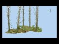 A Look at Full Tree Stem and Forest Plot LiDAR Scans
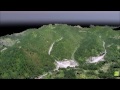 Photogrammetric 3D Forest Canopy Models from UAV / Drones
 3m Resolution Satellite Imagery - Post Flooding Event 2018 Analysis
 Forest Inventory in Virtual Reality - What it is like for real?
 Edge Plots - Installing Walkthrough Mirage Plots Using PlotSafe
 Use of Drones with Thermal / IR Cameras used for Pest Detection
 Fire Monitoring with UAV / Drones and Thermal Cameras
 Drone Technology Providing Vital Information for Firefighters
 Virtual Reality Forest Tree Assessment / Inventory
 Watching a sustainable forest being harvested from space
 LiDAR Forestry Circular Sample Plot with Several Broken Tree Tops
 Using Seek Reveal Thermal Camera in Wildfire
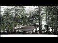 A colourful walk in the forest with LiDAR with a 3D colourised point cloud
 Forest Inventory Using Virtual Reality, Full Tree Assessment Using Ultradense LiDAR
 Using Planet Explorer - Change Measurement Preferences
 High Density Airbourne UAV LiDAR Data of Pinus Radiata Forest - Reviewing a Single Tree
 Drone LiDAR Scanning within the Forest Using Autonomy of Hovermap
 Te Whare Tuteata - Scion Hovermap Scan 2022