QGIS 3D Map using 3D View (Version 3.x)
UPDATED VIDEO: https://youtu.be/GlGBp4zj3vc
Create a 3D map in QGIS using a DEM, hillshade, and Google imagery. In this QGIS tutorial you will learn how to create a 3D map from a DEM an overlay other vector and raster layers to create realistic-looking terrain.
Make an Animation from 3D view: https://youtu.be/ACR37icg8cA
Make a 3D video: https://youtu.be/ig2lywKdufA
Visit opensourceoptions.com for more content and courses
⭐ Kite is a free AI-powered coding assistant that will help you code faster and smarter. The Kite plugin integrates with all the top editors and IDEs to give you smart completions and documentation while you’re typing. https://www.kite.com/get-kite/?utm_medium=referral&utm_source=youtube&utm_campaign=opensourceoptions&utm_content=description-only
Видео QGIS 3D Map using 3D View (Version 3.x) канала Open Source Options
Показать
Комментарии отсутствуют
Информация о видео
Другие видео канала
 QGIS Terrain Analysis: hillshade, slope, aspect (Version 3.x)
 Prepare Study Area Map Easily |QGIS
 How to create a 3D Terrain with Google Maps and height maps in Photoshop - 3D Map Generator Terrain
 QGIS 3D Modelling
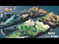 How to Create 3D Terrain with Google Maps and Blender!
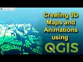 Creating 3D Maps and Animations using QGIS
 Qgis 3d (Qgis2threejs plug in) VISUALIZZAZIONE in 3D. Metodo SEMPLICE
 Modelos Digitales de Elevación 3D qgis2threejs | Qgis 3
 Clipping Raster (DEM) by a Polygon in QGIS
 QGIS 3 for Absolute Beginners
 QGIS Add Google Satellite, Hybrid, Maps, Terrain and other custom basemaps (Version 3.x )
 QGIS Import XYZ coordinates data, Create DEM, Create contours, Add Contours label, Use 3D view model
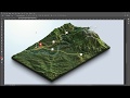 From Google Maps and heightmaps to 3D Terrain - 3D Map Generator Terrain - Photoshop
 Deriving River Network & Catchments from a DEM using QGIS
 How to extract contour lines And DEM from Google Earth
 Make and style hillshade in QGIS 3 tutorial
 Basic 3D Visualization In QGIS (Draping Images on a DEM)
 3D visualization of Data in QGIS
 QGIS: 3D rendering
 Create hillshade 3D views of scanned topographical maps in QGIS