- Популярные видео
- Авто
- Видео-блоги
- ДТП, аварии
- Для маленьких
- Еда, напитки
- Животные
- Закон и право
- Знаменитости
- Игры
- Искусство
- Комедии
- Красота, мода
- Кулинария, рецепты
- Люди
- Мото
- Музыка
- Мультфильмы
- Наука, технологии
- Новости
- Образование
- Политика
- Праздники
- Приколы
- Природа
- Происшествия
- Путешествия
- Развлечения
- Ржач
- Семья
- Сериалы
- Спорт
- Стиль жизни
- ТВ передачи
- Танцы
- Технологии
- Товары
- Ужасы
- Фильмы
- Шоу-бизнес
- Юмор
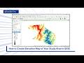
How to Create Slope Map of Your Study Area in QGIS #qgis
Learn how to create a Slope Map in QGIS using Digital Elevation Model (DEM) data in this easy step-by-step tutorial.
Slope maps are one of the most important terrain analysis products, helping to measure the steepness and gradient of the land surface. They are widely used in hydrology, environmental management, agriculture, engineering, urban planning, landslide assessment, and remote sensing applications.
In this tutorial, you'll learn how to generate a slope map from DEM data, select the correct parameters, visualize slope values effectively, and create professional-quality maps in QGIS. Whether you're a student, researcher, GIS analyst, or beginner, this video will help you understand slope analysis and improve your geospatial skills.
Don't forget to Like, Share, and Subscribe for more QGIS, GIS, Remote Sensing, and Google Earth Pro tutorials.
#QGIS #SlopeMap #SlopeAnalysis #DEM #DigitalElevationModel #GIS #qgistutorial #TerrainAnalysis #RemoteSensing #SpatialAnalysis #Geospatial #GISMapping #Topography #Geography #Cartography #OpenSourceGIS #Geoinformatics #ElevationAnalysis #EarthObservation #GISLearning #RasterAnalysis #EnvironmentalMapping #QGIS2026 #MapMaking #GeoData #TerrainMapping #GISStudents #LandformAnalysis #LearnQGIS #SatelliteData
#DEMProcessing #TopographicAnalysis #TerrainModeling #GeospatialAnalysis #RemoteSensingTutorial #GISProjects #SpatialData #DigitalTerrainModel #EnvironmentalGIS #GISResearch #OpenSourceMapping #GeographicInformationSystem #LandSuitabilityAnalysis #TerrainStudies #LandSurfaceAnalysis #GISCommunity #SlopeGradient #ElevationModel #QGISWorkflow #GeospatialTechnology
Видео How to Create Slope Map of Your Study Area in QGIS #qgis канала GeoSkill Pro
Slope Map How to Create Slope Map in QGIS QGIS Slope Analysis Slope Analysis Tutorial DEM Analysis Digital Elevation Model Terrain Analysis Topographic Analysis Raster Analysis GIS Tutorial Remote Sensing Spatial Analysis Geospatial Data QGIS for Beginners Open Source GIS Earth Observation Digital Terrain Model Terrain Mapping GIS Mapping Geographic Information System.
Комментарии отсутствуют
Информация о видео
23 ч. 29 мин. назад
00:05:09
Другие видео канала