Drones over Idaho 2019 Idaho Falls
Please visit my web site www.divexprt.com for complete galleries on these and many more monumental locations there just wasn't space to include here.
These are from my trip to Idaho Falls in 2019 with side trips to Swan Valley and West Yellowstone..
Off the beaten track, I flew over the Ririe Reservoir and its earthen dam. The dam backs up Willow Creek to form a long, skinny reservoir.
Then driving South on Rt. 26, I stopped at charming Fall Creek Falls. Small, but kind of neat, and flowing pretty strongly.
Finally, farther down the highway, I flew twice at Palisades Dam and the huge reservoir behind it.
Once the weather had turned warm and sunny, I tackled the two most challenging flights of the trip. Lower Mesa Falls is 1150 feet distant, and 450 feet down in a gorge. Scary stuff, because the drone has to make the long climb back when the battery is running down.
Upper Mesa Falls must be approached from above after flying above hundreds of tall fir trees. Any mistake with those trees is fatal for the drone.
I also had a chance to fly over some bucolic scenes along the Snake River South of Yellowstone, One thing for sure--Idaho has a lot of water!
To wrap up the adventure, I drove to Mackay Reservoir and Dam in a spectacular setting. I even made a high flight (miraculously missing some power lines by mere inches!) to get an overview of the lake. What a finale!
Видео Drones over Idaho 2019 Idaho Falls канала Carl Roessler
Показать
Комментарии отсутствуют
Информация о видео
Другие видео канала
 Drones over Idaho 2019 Twin Falls
 The Lodge at Palisades Creek.South Fork Snake River. 22 minutes
 USA Road Trip - 28 Days - 2/4 - Bend, Idaho Falls, Shoshone Falls, Craters of the Moon, Yellowstone
 NEW TO THE MARKET! 1154 Crescent Ave, Idaho Falls, ID 83402
 Family Gives Full Tour of Their 20 Acre Off Grid Property In North Idaho
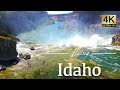 Idaho By Drone - Beyond Boise - Castle Rocks, Grand Tetons & More 4K Travel Footage
 4K City Walks: Idaho Falls, Idaho Town Tour - Virtual Walk Walking Treadmill Video
 Drones over the Central Oregon coast 2020
 NEW TO THE MARKET! 3838 Deer Run Dr, Idaho Falls, ID 83401
 Historic Downtown Idaho Falls
 NEW TO THE MARKET! 230 Monte Vista Ave Houses for Sale In Idaho Falls Idaho 83401
 Fishing the Snake River and a Ririe Reservoir | Idaho Falls
 Hidden Springs Idaho
 Drones Above the West Part 6 the Year 2020
 Destination Idaho Falls
 NEW TO THE MARKET! 3378 Greenwillow Houses For Sale In Idaho Falls
 Paradise in Idaho: Boondocking the Snake
 Idaho's Conservation Officers
 A Guy and His Gal Base Jump Off the Perrine Memorial Bridge in Twin Falls Idaho During Quarantine!!
 Drones above Idaho 2016 Part 2